 |
| Courtesy Stanley Saitowitz / Natoma Architects, Inc. |
For several years, the City of San Francisco has worked to develop the Market & Octavia Neighborhood Plan, studying neighborhoods centered on the pivotal intersection of Market and Octavia, bookended by Church Street on the west and Van Ness Avenue on the east. The plan was one part of the Better Neighborhoods 2002 effort — a sadly ironic name, because a mere 365 days is nowhere near sufficient to start and finish such a large-scale planning process, particularly in San Francisco. In some areas covered by the Market-Octavia plan, one has the impression of being in an unclassifiable neighborhood that is nonetheless quite close to favorite, well-established locales. The plan encompasses an area historically known as “the Hub”, so named for the Muni turnaround located there, and the neighborhoods contained within the plan area continue to evolve and come into their own, coining names like Deco Ghetto to reflect both an emerging identity and broader acknowledgment of that identity. Other parts of the plan area, including Hayes Valley, already enjoy established commercial districts but have been given a new chance to blossom since the retreat of the Central Freeway to the south side of Market Street.
It is also in this area that the slanted South of Market street grid curves and reorients into an arrangement that reflects the cardinal directions, adjusting to form the Mission/Castro grid. This is a departure from the pattern firmly established all the way from the Ferry Building, resulting in a suspension of the security resting in the predictable pattern of downtown streets. But some clever planning could take advantage of this insecurity and transform it into a distinctly urban sort of excitement, in which even the unsuspecting pedestrian would be smoothly guided by intuitively navigable streets designed for humans, rather than for the sole function of moving automobiles efficiently.
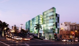
Market-Octavia is exactly the plan that aims to knit these disconnected neighborhoods together into a more unified and walkable set of districts that San Francisco could rightly be proud to call its own. The plan reflects thoughtful cooperation between community members and city planners. This vision was not forcefully hoisted upon neighborhood residents; rather, the goal was to achieve a consensus. It simultaneously blends a respect for the eminently livable residential scale of San Francisco’s most beloved neighborhoods, while advocating for a forward-thinking vision of elegant density graced by moving examples of contemporary design, like the Octavia Gateway pictured above — a building that provides a splendid answer to the problem posed by the narrow, awkward parcel of land on which it would sit, at the northeast corner of Market and Octavia.

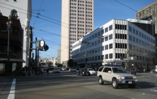
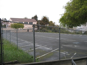
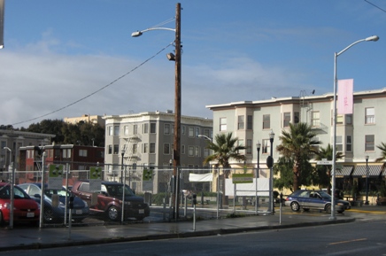
As indicated in the above map, the plan appropriately focuses higher residential density on the neighborhood’s primary thoroughfare and transit corridor, calling for a streetwall 80-85 feet tall, with infill opportunities along and immediately off of Market Street itself — and milder heights of 30-45 feet deeper in the neighborhood. The plan concentrates the very highest densities in a Special Use District (SUD) centered at the intersection of Van Ness and Market, in which slender towers (up to 400 feet tall) placed directly on top of the Muni Metro Van Ness station would step down to about 120 feet within a couple blocks of the intersection. Such a plan could immeasurably improve the highly disappointing intersection of Van Ness and Market. By all rights, this intersection should be an energetic centerpiece of the city landscape — but it has little in the way of pedestrian amenities, and its low-rise frontages are a huge letdown:

Not only that, but it is scarred by that cardinal urban sin: underutilized space in the form of surface parking:

Hardly impressive for the meeting of two of the City’s greatest boulevards. Landmark towers alone would not transform this intersection into a real place, but they could be an important part of the formula. Streetscape improvements carried out as part of the Van Ness bus rapid transit project, including perhaps especially carefully designed stations at Market and Mission, are yet another component. The Market-Octavia plan also paves the way for the creation of a dense, mixed-use “SoMa West” neighborhood and new open space, centered on the area in which Mission Street splits into the one-way pair of Mission and Otis. To account for the increases in density and some 6000 additional housing units, the plan area is designed not only to discourage private auto use, but correspondingly to aid smoother passage of surface transit and to create a streetscape more attractive and friendly to both pedestrians and cyclists. The northeast end of the neighborhood would connect to the proposed bus rapid transit corridor along Van Ness Avenue, itself a corridor with some two thousand units of infill housing under construction and in the pipeline.
Years after the planning process was initiated, the version of the plan adopted last year continues to be subjected to further amendment that actually brings it closer to the admirable intent of the 2002 draft plan. Three contentious issues have dominated recent discussion at the Board of Supervisors: affordable housing, parking limits, and density caps — in particular, how those issues would interact with sub-districts contained within the plan area. In addition to the Market/Van Ness SUD, areas such Market Street west of Franklin are designated as Neighborhood Commercial Transit (NCT) to encourage active retail uses on the ground floor, an uninterrupted streetwall along Market, and any parking to be accessed from the rear. The last category, Residential Transit-Oriented (RTO), covers the more low-rise residential blocks tucked further in behind Market, including parts of Duboce Triangle and the Lower Haight.
First, the affordable housing fees. Supervisors Mirkarimi and McGoldrick had earlier agreed to implement an across the board $10/square foot impact fee on developers to be applied to affordable housing, which McGoldrick continues to support. Mirkarimi later suggested a tiered system to avoid punishing small developers who would be hit harder by a $10/square foot fee. Under this tiered proposal, developers would pay $8/square foot for projects located in the Market/Van Ness SUD, $4/square foot for NCT projects, and no fee for projects in the RTO area. In addition, Mirkarimi’s proposal suggests that in lieu of purchasing TDRs to exceed maximum allowable FAR in the Market/Van Ness Special Use District, developers could contribute $30/square foot to the city affordable housing fund. These fees would be imposed in addition to other fees raised for impacts related to parking and transit.
The second source of dispute is the parking. Planning had relaxed the limits originally proposed in 2002, which elicited protest from neighborhood residents (notably the Hayes Valley Neighborhood Association) who were quite justifiably upset at the prospect of encouraging more auto use and degrading the livability of their streets. McGoldrick’s amendment on parking was geared to be attractive to families, pushing for one-to-one parking for family-designated housing (at a minimum of two bedrooms and 1000 square feet). Mirkarimi’s version, on the other hand, is comparable to the original recommendations from the 2002 draft plan; indeed, even slightly stricter, with a 0.25 parking ratio in the Market/Van Ness SUD and 0.5 for areas designated NCT and RTO (with up to 0.75 in the RTO under conditional use). There is now general agreement to adopt these stricter limits.
The third and last major source of dispute is the RTO density soft cap, which would require conditional use for projects building more than one unit for a 600 square foot area. Duboce Triangle neighbors pushed this cap for just their own corner of the plan area, and Mirkarimi’s proposal maintains the cap for Duboce Triangle but removes the cap for RTO blocks outside of Duboce Triangle. McGoldrick’s proposal, in accordance with the Planning Commission’s recommendation, would apply this cap for all units in the RTO zone (exempting permanently affordable units), to prevent unit subdivision from encroaching on the supply of family-sized housing.
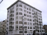
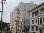
Opponents would point to the removed density cap in Mirkarimi’s amendment as evidence that the Market-Octavia plan flies in the face of the historic architectural context that defines the neighborhood and introduces unsuitable and unmitigated levels of density, but practically, the density we would see built is limited not only by the plan-specified heights but also by emphasis on the creation of housing intended for families: a minimum of two bedrooms and 1000 square feet. Moreover, the assertion that the proposed heights would overwhelm the neighborhood and dwarf existing structures is absurd. Several older apartment buildings already exemplify what the maximum allowed height would be in the plan area, excluding the Market/Van Ness SUD, which is the plan’s sole provision for high-rise density. And in some cases, existing buildings already exceed the heights specified in the plan. Consider the following examples. What do you think: are these overwhelming? Do they tower offensively over the neighborhood?

Opponents also present Market-Octavia as though it is a drastic change that will irreparably scar the landscape; but in a very real sense, the plan simply formalizes what we have done all along when building city neighborhoods — or, more precisely, what we once did. Perhaps the major difference is that although our neighborhoods were first built in the era of the streetcar, we find ourselves now in the age of the private car. Modern reliance on the automobile handicaps our ability to manage density without simultaneously chipping away at that reliance — both negatively by limiting parking, and affirmatively by designing a streetscape that encourages walking. Market-Octavia is not about razing blocks of Victorians to the ground and erecting skyscrapers in their stead. With the exception of the Market/Van Ness SUD — just one small corner of the plan area — the plan is strictly low- to mid-rise, but more importantly, it provides a set of guidelines to govern infill opportunities, so that any infill developments are consistent with a general desire to promote livability by emphasizing the neighborhood’s transit orientation. Market-Octavia is not about creating a new neighborhood, but rather, about enhancing and providing cohesion to a collection of neighborhoods that in many ways are already quite successful, but that could be even better.
In some sense, it boils down to the following question: do we want to preserve this?
Or would we rather have more buildings like this?

Yes, the plan area is full of lovely, modestly-sized Victorians, but they are largely located in RTO blocks with the milder 35-40 foot height limit. Heights in those blocks were so specified in order to respect and preserve this comfortable, characteristically San Franciscan residential streetscape. And even if a three-story Victorian and an eight-story apartment building are juxtaposed (as occurs in one of the above images), is that really so bad? Is it not precisely this sort of architectural variety that adds a distinctly urban interest to the street environment? Did I miss an executive decision requiring that every building on a given block be of identical height and architectural style, and that every block in a given neighborhood look identical? Encouraging taller buildings to front onto Market Street and to be built to the property line will help to emphasize the angularity of Market Street intersections and heighten visual excitement on what, after all, is (or should be) San Francisco’s most impressive thoroughfare.
 The Market-Octavia Plan is the product of extensive community involvement spanning the better part of a decade. That community input has been undeniably invaluable in terms of taking a great initial idea and developing the details. And yet, no plan, however sound, can ever be perfect to all people; drag our feet too long, and we risk losing sight of what makes the underlying spirit of the plan so special in the first place. And all the while, fences and remaining empty lots along Octavia are wounds in the urban fabric — to be sure, no longer shrouded in the darkness of a freeway, but nonetheless still not fully healed. So much unrealized potential: yet once the dust settles after almost a decade of discussions, neighborhood meetings, environmental review, negotiations, and squabbles, we may at last enjoy watching this keystone district in the heart of the City transform into a vibrant hub of neighborhoods.
Full size images are hosted on my Flickr account.


very well said. The sudden nimby opposition to 55 laguna boggles the mind. I an not sure why anyone is suddenly attached to surface lots.
Posted by Stephen | 1 April 2008, 1:23 pm55 Laguna is trickier because it involves rezoning public land — some people really do just have historic preservation in mind, while others will jump on that bandwagon when they actually just don’t want to see a few hundred extra homes. This post was already getting way too long, so I didn’t get into it — hopefully 55 Laguna will be addressed in a separate post.
Posted by Eric | 1 April 2008, 1:26 pmThanks for putting together such a detailed and informative post. It looks like a great plan overall–if I were free to impose one by fiat, I don’t think I could come up with one more to my liking.
I do worry about the intersection of Market and Van Ness, though. It’s such a focal point that it deserves a landmark of some sort, and a few moderately-tall commercial buildings aren’t going to cut it. Too bad Don Fisher is so set on the Presidio, because it would be a dramatic place for a museum with a Tate-esque public presence.
55 Laguna appears to be going forward. It cleared the Land Use Committee last night and is headed for the full board, where Sup. Mirkarimi says it has strong support.
Posted by haighterade | 1 April 2008, 8:03 pmHaighterade, I am really fond of Market-Octavia, as well, which probably came through in the post — it probably ranks as one of my very favorite things going on, right now. And I am very excited to see what these neighborhoods will look like once we have projects proposed under the new zoning.
Regarding Market & Van Ness: I agree with you, this intersection needs more than just a few towers, even if they are well-designed and interact well with the street. It also needs more than a few towers and a BRT station. If San Francisco were any European city, this intersection would be something spectacular, with a beautiful monument at the center. This intersection really deserves to be carefully thought out as a civic centerpiece.
Posted by Eric | 1 April 2008, 8:26 pm