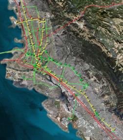
 This post will lay out a guide for future bus rapid transit expansion in the East Bay; it is the companion to a San Francisco BRT post from a couple months ago. The map at right (click through for a full-sized map, hosted on Flickr) is a visual depiction of what a future rapid bus network might look like. Just for reference, rail corridors are marked in red. As on the San Francisco map, the BRT corridors here are categorized into yellow and green. Yellow represents the most important corridors, streets that should receive full BRT treatment, including dedicated right of way, signal preemption, station platforms, ticket machines, and NextBus screens. Green represents secondary corridors that are lower priority than yellow corridors, and would receive a subset of full BRT treatment. The green label is slightly misleading in that not all green corridors are equivalent. There are several reasons why a corridor may have been labeled green — in most cases because the street is too narrow to create bus-only lanes, ridership is not terribly high, or serious enhancement is unnecessary. College Avenue, for example, currently served by the 51 bus, is marked in green, while Broadway, also served by the 51, is marked in yellow. Despite the narrow street width, service on College could be improved by removing a few lightly used stops and giving buses priority at traffic signals. Other enhanced green-colored corridors include crosstown lines on Ashby Avenue in Berkeley and Fruitvale Avenue in Oakland; Solano Avenue in Berkeley and Albany; Shattuck Avenue between Telegraph and Adeline; and routes that connect Emeryville to MacArthur BART station, West Oakland, and downtown Oakland. Enhancements have been added along the Alameda portion of the 51, and this route has been extended slightly to terminate at Fruitvale BART. Additional service could operate only within Alameda, connecting to ferries and development at Alameda Point.
The bona fide BRT corridors, marked in yellow, are AC Transit’s highest ridership trunk routes; some of these would also be natural candidates for future upgrade to light rail. They are placed on Broadway, Telegraph Avenue, San Pablo Avenue, East 14th/International, University Avenue (extending all the way to the Marina to meet ferries), and the downtown Berkeley/Gourmet Ghetto section of Shattuck Avenue. The improvements for Telegraph and East 14th marked on the map represent the BRT project that is currently underway, and the rest of the network is projected around this initial line.
The Grand/MacArthur corridor seems like another candidate for full BRT treatment. Unfortunately, mere wisps of one-way streets on either side of Interstate 580 make it difficult to introduce bona fide BRT on the whole corridor, though it is easier to do so west of Piedmont Avenue and east of Fruitvale Avenue. In any case, I marked MacArthur — and its extension past Eastmont along 73rd Avenue to Oakland International Airport, per the 805 line — in green rather than yellow, but the more spacious sections of the street offer the opportunity to build a fuller complement of BRT-like features, including transit-only lanes.
Another question is what sort of enhancement should be added to downtown Oakland. Here is a portion of the above map, zoomed in on downtown:

Downtown Oakland is served by a lot of buses, but those buses basically just pass through, with many lines using a Z-shaped route traced out by 20th Street, Broadway, and 11th/12th Streets. As a result, these buses are an excellent way to travel between downtown and an outside neighborhood, but they do not provide a convenient way to move within the downtown area itself. Currently, if one wants to go, for example, from the Gold Coast neighborhood to Old Oakland without driving, the best option is pretty much just to walk, even though the trip is over a mile long. There ought to be a better option, especially as downtown fills up with new residents. AC Transit is aware of the issue; most recently, in the 2007 performance report (PDF found here), right after a brief mention of Small Starts funding for MacArthur BRT, there is a note:
Downtown Oakland Plan – Staff has incrementally clustered service on the 11th/12th and 20th Street corridors, and plans to work toward an overall formal transit priority streets plan that would increase service, access and reliability throughout the downtown area.
A long-term goal, and still quite general, but it’s a start. Steve from SF Cityscape has drawn up a very nice prototype of a downtown loop with a clean, intuitive route. In the above map, I drew in a different line that would serve a similar purpose — the route is less intuitive, but it circles around service-laden Broadway instead of running directly on it. This downtown service could connect to the enhanced bus corridor on Grand Avenue, as well as to the 19th Street and Lake Merritt BART stations; it would skirt the west side of City Center. New service has also been added to serve an eventual development at Oak to Ninth. Depending on demand, Oak to Ninth service could consist of fairly minimal connections to major transfer points (e.g. Amtrak and 12th Street BART), or it could be a component of a larger route connecting the Jack London Square, Eastlake, and Grand Lake neighborhoods.


Nobody has ever upgraded a BRT treatment to light rail; nor has anybody ever identified exactly how that would be done (Houston got closest, with their plans to build rails and then cover them with asphalt, thankfully rethought since then). BRT would obviously have to run in the center lane with real stations (unlike how it’s almost always done here) – but even then platform heights are unlikely to be compatible, and it’s unlikely you can just assume you’ll put up caternary ‘later’ and it’ll all magically work out…
In short, anybody who believes this tripe about “BRT now, LRT later” is being incredibly naive. It’s never going to happen that way.
Posted by M1EK | 5 April 2008, 11:30 amM1EK, based on your previous comments on this blog and other blogs, I know that you are staunchly anti-BRT, and you stick very closely to this principle despite apparent lack of familiarity with the local context to which you automatically apply it. Given this bias, your implicit assumption here appears to be that my support of building these BRT lines is predicated upon a future upgrade to LRT. That assumption is false, which is why I gave the thought a mere one sentence (out of a rather long post) — so as to say that if the upgrade were to occur, some subset of those corridors would be the proper place. But for most or all of these corridors, BRT will do the job quite nicely now and for the indefinite future.
Instead of a simplistic one-size-fits-all type of solution, my main point here is that we should actually try to customize transit improvements (gasp) to the corridor those improvements are planned to serve.
Posted by Eric | 5 April 2008, 7:11 pmInteresting look at potential BRT projects in the east bay.
It’s not clear how your Downtown Oakland circulator route would operate. I think Steve’s proposal links to more activity centers, although I like the concept of serving the areas west of Broadway where new development is occurring. Perhaps two separate loops would work, with each loop overlapping on Broadway with a timed transfer?
Also, your BRT proposal seems to give very short shrift to East Oakland. There are only two cross town routes (East to West) linking MacArthur to International south of Downtown (and no full BRT) in an area with over 200,000 people, many of whom are transit dependent. In contrast their is a high density of E to W routes north of Downtown Oakland. While the street grid is more favorable north of DTO, the lack of E to W connectivity in East Oakland has to be addressed. Also, why no full BRT bus lanes on MacArthur or Foothill? Yes, these areas congested but would probably have better ridership than some of the North/Central Oakland routes.
Finally, was there any attempt to rationalize which routes would be most effective? The lines on a map are great, but how does this connect with future ridership?
Posted by ChinaNobDweller | 6 April 2008, 12:15 pmChinaNob: Remember that this isn’t a complete map of bus routes. It’s simply a map of where it makes sense to carry out substantial improvement in the form of infrastructure. There will obviously be standard local buses operating as well, not marked on the map, including several in East Oakland. In addition, some routes that were cut several years ago could be reinstated and would fill in the grid, even if they do not receive infrastructure improvement; those are also not marked here.
It’s not clear how your Downtown Oakland circulator route would operate.
Yeah, it’s a little unclear because it’s all superimposed on one map. It follows parts of other routes on the northern edge, uses San Pablo/Clay on the west side, loops down to Amtrak, and uses Oak/Jackson on the east side. If Oak to 9th happens, it could go there as well, or that could be run as a separate service. The route is a bit convoluted, but the whole point there is actually to avoid Broadway, and have better service in other parts of downtown. The main activity centers that you would serve going down Broadway are 14th Street, City Center, and Old Oakland. Running a bus on Clay allows you to serve all those areas just as well, but on the western edge, and you’d still catch the edge of Chinatown. The downtown loop does provide direct service to Uptown. So it hits all the major downtown districts, and it connects directly to 3 of the 4 rail hubs.
There are only two cross town routes (East to West) linking MacArthur to International south of Downtown (and no full BRT) in an area with over 200,000 people, many of whom are transit dependent.
You could put in a couple more (in fact, I have, on different versions of this map), but you have to bear in mind what these streets actually look like. Many of these streets are narrow, residential, not particularly dense, and not future candidates for more intense land use beyond some modest infill. That is why “full BRT” wouldn’t be appropriate in many cases — it wouldn’t happen, and on many streets, it’s not even necessary. These crosstown routes have only a couple thousand or fewer daily riders, and service could be improved without making an infrastructure investment — as such, they have not been marked on the map. Also, certain routes could provide greater connectivity, e.g. the 53 that doesn’t run deeper into Dimond could run along MacArthur to the Laurel District or Mills College, instead of terminating at MacArthur. There are ways to play around with this that it’s not very easy to depict on the map. It’s important to keep in mind both what this map is, and what it isn’t.
Finally, was there any attempt to rationalize which routes would be most effective? The lines on a map are great, but how does this connect with future ridership?
Of course — that was the whole point of this post. The greatest potential for future development and increased ridership is precisely along the corridors that are marked in yellow. Using a map is a simple and visually appealing way of representing the underlying ideas, but there is a lot going on here beyond simply drawing lines on a map.
Posted by Eric | 6 April 2008, 1:12 pmI’m increasingly pessimistic about BRT in the East Bay for a variety of reasons, not the least of which is:
http://oaklandliving.wordpress.com/2008/04/02/berkeley-initiative-could-endanger-future-transit-projects/
But putting that aside for the moment: This strikes me as a sound proposal, Eric. I’m curious about existing ridership on the Ashby line (#9). Does anyone have ACT route-level ridership numbers lying around?
Needless to say I prefer my downtown circulator ;-) Seriously, though, despite a few large office buildings, the difference in foot traffic between the west side of downtown and Chinatown is like night and day.
One silver lining that could come out of the collapse of an InTel transitway (although one of the advantages of BRT is that it’s not an all-or-nothing proposition–dedicated lanes in East Oak alone could cut run times significantly, and that’s where the bulk of the ridership is) is that more attention, at least, might be paid to incremental upgrades on various routes, as Eric has proposed. Just improving to “quality bus” on trunks could make a meaningful difference in the everyday experiences of tens of thousands of riders.
Posted by Steve | 8 April 2008, 10:37 amYeah, I saw that post, definitely not encouraging. Even getting one mile of BRT is proving to be a real chore. But if necessary, the project could be scaled to just the Oakland city limit, I guess depending on what happens with the San Leandro end.
The route ridership levels (gathered in Fall ’07) are in that same PDF linked in the post, although the system-wide count implied by the figures in that PDF run short of the usual system-wide FTA figure that is reported. Ridership on the 9 isn’t too high, about 2,000 a day. The width of Ashby (to say nothing of the Ashby neighbors!) is a limiter to doing all that much there, and it’s basically just residential anyhow.
I thought you might prefer your circulator ;-) Actually, I sort of do, too, though I still think there is value in adding service off of the Broadway spine. Thinking on it more, it might make more sense to just work the west side of downtown into a trunk route, or maybe just a realignment of the 19. Having an intuitive route for the loop does go a long way to make it more popular — I mostly just thought I’d play around with something else for fun, and for the conversation. Foot traffic (and car traffic, for that matter) is much lower on the west side, as you noted, but some sort of service would be nice as that side of downtown emerges with more homes and offices. On a related note: Old Oakland is basically filled up in terms of store space, but it hasn’t taken off nearly as much as I had hoped it would several years ago.
Posted by Eric | 8 April 2008, 10:55 amYou know, the productivity numbers on Route 62 (44/hr.) suggest another crosstown between Grand and Fruitvale might make sense. You’re right that conditions are constricted, but Highland Hospital has got to be a significant trip generator.
Posted by Steve | 8 April 2008, 11:42 amI’m sorry, *Lakeshore* and Fruitvale. Too long out of the 510.
Posted by Steve | 8 April 2008, 11:53 amI’ve sort of wavered back and forth on adding crosstown improvements on 14th Avenue, but it could be a natural choice, not only because of Highland, but also because it’s one of the wider streets in the area.
Posted by Eric | 8 April 2008, 12:43 pmOn another note, the stretch from East 14th to MacArthur is short enough that these crosstowns don’t always make sense in isolation. A question I find more interesting is what makes the most sense in terms of connecting crosstown corridors to each other. Is that status quo really the best option? I wish we had TEP-style statistics for these routes.
Posted by Eric | 8 April 2008, 12:52 pmSo that Lakeshore leg … that’s connected to what? I can’t quite tell from the map.
Posted by Steve | 8 April 2008, 2:14 pmLakeshore isn’t really a big rider market, probably at least in part due to the 13’s relatively limited schedule and service range, so I was considering the possibility of adding extra branches to the 13, beyond the one going to Mandana — maybe something like the northern part of the 12 that links a few of the local commercial strips. Another choice would be to turn east. When you asked that, did you have some sort of Eastlake loop in mind, using 14th Avenue?
Posted by Eric | 8 April 2008, 2:47 pmPerhaps. Or take whatever you’re routing down Lakeshore and run it on 14th Ave instead. As much as the idea of quality transit around the Lake is appealing (I still dream of a streetcar loop), I suspect Lakeshore, like Ashby, might not merit the investment.
Posted by Steve | 8 April 2008, 3:15 pmYeah, you might be right. For sure, a streetcar around the lake would be best of all.
I’m of two minds about places like Lakeshore. Adams Point and Eastlake are some of the densest East Bay neighborhoods, probably on par with parts of the Inner Sunset/Richmond, so it’s not like the potential riders aren’t there. And yet, ridership in these dense neighborhoods is just a fraction of what it could be. That has to be due, at least in part, to meandering, less frequent routes operating in this area. Just looking at the numbers, I would agree that these places may not be worthy of BRT-type investment, but I can’t help but feel that we are falling short of tapping a rich resource in these inner ring neighborhoods that fall just short of being comfortably transit-oriented.
There’s something comforting in knowing that you’re never too far from a frequent and reasonably quick transit line, even if it doesn’t have dedicated lanes. I think this sense of security could well make or break it for many people in terms of becoming devoted riders. AC Transit carries about 1/3 of Muni’s load in a much larger geographic region, so the comparison can’t be a direct one — but while a great deal of San Francisco is a short walk from a major, frequent route, this is much less true of the East Bay right now. That’s something I’d really like to fix, at least for Oakland and the main Berkeley grid. I suppose that’s really why I included some of these less important corridors. By that line of reasoning, I probably ought to have also included 14th Ave, 23rd Ave, High St., etc., maybe even Alcatraz — but then the “is it worth the investment” question creeps in again.
Posted by Eric | 8 April 2008, 5:57 pmYou make a good point. Existing ridership is far from everything.
Posted by Steve | 9 April 2008, 12:01 amIn any case, secondary corridors will probably be a pretty academic question for awhile, until AC works out all the main trunk lines. And who even knows about the Berkeley half. I can’t imagine residents will be too happy about removing lanes on University.
Where did that benevolent pro-transit dictator run off to? ;)
Posted by Eric | 9 April 2008, 7:19 amEric – thanks for posting this – I’ve been waiting for it ever since you posted your SF version.
Though I wrote about the anti-BRT initiative, I’m still very hopeful about the current BRT project and future projects. We have a good crew of advocates working to debunk the myths put forward by the opposition and we’re going to embark on further outreach (especially to bus riders).
I think it’s interesting that there is a small group of hardcore transit supporters who think BRT is worthless and that we should only be fighting for rail. The reality is that the neighborhood groups would be fighting us even more if we were proposing a rail line because it would use more traffic lanes and parking space. Also, rail is significantly more expensive. Though I support rail in some cases, I agree with Eric that BRT is especially suited for parts of the East Bay.
On the downtown issue – this has to be one of the most frustrating parts of being bus dependent. It is actually quicker for me to walk from 14th and Webster, where I work, to the Amtrak station (sometimes I take the train to Sacramento) because no bus lines take me directly there. We really need a better downtown bus loop.
Posted by Becks | 9 April 2008, 5:48 pmHi Becks, yeah, sorry about the delay on that. I had it partially finished, but then life got crazy, and Google kept losing the line input data for some reason. Then, in the middle of it, Google also updated its Bay Area satellite images, so I basically had to start it over. It took longer than I was hoping, but thanks for your patience.
Thanks also for your and others’ work in promoting the importance of the project and debunking the myths. I’ve been hoping to help participate in that effort, as well; getting to North Berkeley on a weekday evening isn’t particularly easy, but maybe sometime soon.
There is a schism of sorts in the pro-transit community, in part brought about by worthy light rail projects being downgraded to BRT to save money — and a backlash of sorts, because there is also a subset of people who extol BRT so unconditionally as to say that building BRT is in every sense equivalent to building rail, only with buses. Which it isn’t, of course, but dismissing BRT just because it isn’t rail seems silly to me. In some places it really makes sense.
Quite frankly, I can understand the anti-BRT sentiment, as it applies to some cities across the country that are just beginning to build a real transit network. These cities deserve to have a dedicated rail network at its foundation that buses can feed into, both to encourage higher transit usage and to provide natural corridors for more intense land use. That’s how you begin the process of creating a more livable, transit-oriented city.
Here in the Bay Area though, for all of BART’s faults, we are blessed to already have a rapid system that unites a great deal of the region (even if we are still far from maximizing the land use potential of that system) — and with dozens of other operators besides. At this point, we’re not starting from scratch, but expanding and improving. If one goal is to increase ridership, another goal just as important is to improve service quality for existing riders. BRT works to fill in exactly this sort of niche.
Posted by Eric | 9 April 2008, 10:04 pm1. Light rail is not happening any time soon in the East Bay. Even if Light Rail > BRT, there will not be Light Rail, so if BRT > nothing then BRT would be good.
2. The allignment for BRT close to the UC campus is a problem. While there is bad nimby-ism in Berkeley, there is also valid concern about access to campus.
3. I wonder if a better BRT model would be less North-South and more East-West. BART moves N-S very well, so if there were spokes out from BART it could enable people to get to and from BART more easily.
I realize there is a problem of paying two fares for BART and BRT, but perhaps some sort of East Bay Pass could be worked out (like the Muni pass letting you ride BART free in SF, maybe there could be an Oakland-Berkeley-San Leandro pass).
Posted by MikeD | 10 April 2008, 12:30 pmLight rail will not be happening anytime soon, but it is a point of discussion basically every time the idea of BRT is raised.
Mike, while it’s true that BART moves well for north-south trips, it is also inadequate for a great many local trips. The stations are simply too far apart. BART only works for local trips if you happen to be traveling between neighborhoods lucky enough to get a station. BRT and BART may have the same geographic orientation, but they serve two different purposes.
The problem with BRT on a crosstown (i.e. East-West) corridor is that those routes are in general very lightly used in the East Bay. The major trunk routes with highest ridership are the major north-south routes, i.e. the 1, 51, and 72. These also happen to be the corridors with the widest boulevards that more easily accommodate a dedicated transitway. In the long-term, it would be nice to create a BRT network with both types of routes, as indicated in the map. But it makes more sense to invest first in a corridor with 20,000 daily riders than one with 2,000 daily riders. A good first step on the crosstown routes is to increase service frequency to make these buses a more viable method of accessing BART stations.
Posted by Eric | 10 April 2008, 12:48 pmEric – You’re welcome, and there’s a long way to go on this project so we could use your help at any juncture.
Mike – Your second point threw me off a bit. I’ve heard dozens of arguments about the BRT project, but never have I heard anyone complain that it would create campus access problems. In fact, the University whole-heartedly supports BRT, partially because there’s a huge parking problem on campus and UC Berkeley rightfully believes BRT would mitigate some parking issues.
As a former UCB student who lives on the BRT route, I know that BRT would have made my life a whole lot easier. Also, living on Telegraph, every day I see students parking in North Oakland (where there are no parking time limits) and hopping on the 1/1R. While I don’t think this is a perfect arrangement, these students would certainly benefit from BRT. And with more reliable service, maybe they wouldn’t have to drive at all and could just ride BRT from wherever they live.
Posted by Becks | 10 April 2008, 10:48 pmAs I understand it, there has been some difficulty resolving where the route would go between Telegraph/Dwight and Downtown Berkeley BART. Proposals include reducing Telegraph to a single lane of traffic or closing it to cars alltogether and making it a two-way street for busses only. The former would result in substantial delays when cars park in the street (which happens often), while the latter would route substantial traffic up a block to Bowditch.
Ultimately I think if some street directions are switched a solution can be reached (and as I understand it, Berkeley has switched the direction of one way streets in the past).
Posted by MikeD | 11 April 2008, 9:24 am