I’ve already written a few posts tracking the excitement surrounding the design competition for the Transbay Transit Center and its associated signature tower, but now the real fun begins of planning and constructing a major infrastructure project. The time has come for a post on a crucial, but completely unglamorous subject: the temporary Transbay Terminal, the more-or-less final schematic design of which was presented at a meeting I attended a couple weeks ago. The future Transbay Transit Center is located on the site of the current Transbay Terminal. Since the construction of the former requires demolition of the latter, another site must temporarily house all regional bus operations that serve the terminal. That temporary site is south of the current terminal, namely, the block bounded by Howard, Folsom, Main, and Beale Streets:

The above image faces south. This block is slated for future development on the north and south parcels of the site, with a park in the middle. Of course, development of this block can only occur once bus operations have moved into the new Transit Center. The approximate timeline here is that the whole process of design development, traffic modeling, signal engineering, and the production of documents related to construction will occur for the rest of 2007 and into 2008. The bid process will run through spring and summer of 2008, with an anticipated start of construction in the fall of 2008; construction will continue well into 2009. The above graphic shows the East Loop that covers part of the site. This loop cannot be demolished until the current terminal is no longer operational, so the construction of the temporary terminal is necessarily phased. The first phase will cover construction of most of the block; when that is complete, AC Transit and Greyhound buses will relocate to the new site in approximately July 2009. Then, the East Loop will be demolished, and the second phase of construction will occur in the northwestern corner of the site. The entire temporary terminal should be fully operational by fall of 2009. It is anticipated that the new Transit Center will be completed in 2014, so the temporary terminal would have a five-year life span.
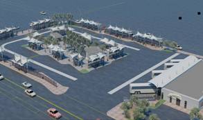
The temporary terminal will be less of a “terminal” and more of a carefully structured parking lot with many bus stops. A Greyhound facility will be located on the southern Folsom-side portion of the site, but there will also be an office for security and customer service, restrooms, and an AC Transit site office. Since the temporary terminal will be used for five years, a great deal of effort has been put into planning a site that is both functional and reasonably pleasant. Planned amenities include bike racks, canopies at bus stops, benches, lighting, and landscaping that includes mature trees. I was pleased to learn that the designers are thinking carefully about clear signage and wayfinding; this will be important since many services will be operating in a confined area. In addition, because the temporary terminal will have fewer bus bays than we have now, there will need to be faster turnover of buses. The cash farebox is too slow to accommodate the necessary turnover rate, so work will be done to ensure that these buses are equipped with Translink fare machines — or, if Translink continues to be delayed, a Translink-compatible system. Here is a rendering of the temporary terminal:
The following graphic gives a good sense of the planned traffic flow through the site and surrounding streets:
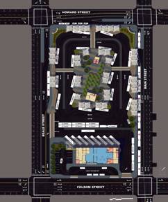
Bus bays will be located on a central island. Three major crosswalks will lead to this island from Main, Howard, and Beale Streets. To ensure pedestrian safety, clear signage and other site features will direct pedestrians to access the central island via one of these crosswalks. AC Transit operations will run entirely on the interior of the site, and the Greyhound facility will occupy approximately 8,500 square feet on the southern end. WestCAT will also be on the interior, while SamTrans and Muni will be on the edge. Placement of Golden Gate Transit buses seems to be less systematic.
In terms of traffic circulation, the basic idea is that transit-only lanes on the surrounding streets will replace the aerial loops that currently connect the Transbay Terminal to the Bay Bridge:
- On the north side of the site, Howard Street will have an island used by Muni to drop off passengers on the 1-California, 5-Fulton, 20-Columbus, and 41-Union lines.
- On the east side of the site, Main Street will be one-way northbound traffic, with a northbound transit-only lane. Muni will use an island to pick up passengers on the 38-Geary, 38L-Geary Limited, and 71-Haight/Noriega lines. Muni bus layover time would also occur on Main.
- On the south side of the site, Folsom Street will have a single westbound transit-only lane which will run as far as the Essex Street entrance to the Bay Bridge. There will also be an eastbound transit-only lane for AC Transit buses. There are no islands on Folsom, but there will be an area on this side of the site for car and taxi drop off.
- On the west side of the site, Beale Street will be mostly one-way southbound, except for the south side of the block, which will have a partial northbound lane that provides access to the interior of the temporary terminal site. There will be a transit-only southbound lane on Beale, and an island used by Muni to drop off passengers on the 38-Geary, 38L-Geary Limited, and 71-Haight/Noriega lines.
During the middle of the day, buses will be stored underneath Interstate 80. AC Transit storage will be in the area bounded by Perry, Stillman, 2nd, and 3rd Streets; Golden Gate Transit will use the same block, but between 3rd and 4th Streets.
Although minor changes could be made, the TJPA seems to be committed to this schematic design for the temporary terminal. The site is limited; indeed, no more than 12 additional afternoon peak hour buses could be accommodated, so it is unlikely you’ll see any service expansion on these bus lines for the next several years. Still, the space seems to be used fairly efficiently. A simulation carried out this past summer at the Alameda Naval Air Station illustrated that the site is squishy but can accommodate the bus schedules for these several transit agencies. Another simulation will be performed on the actual site before the temporary terminal opens.
All three images above courtesy Transbay Joint Powers Authority.


You may have missed your calling as an urban planner.
Posted by Doug | 4 October 2007, 9:01 amIs that a nice way of conveying your opinion that this post is full of boring details? ;-)
Posted by Eric | 4 October 2007, 9:32 amWhere is the Taxi stand? Remember Taxis?
Posted by Cycleogical | 17 August 2010, 5:37 pmCycleogical — just so you know, you’re commenting on a post that’s nearly three years old. All of your inquiries should be directed at the official Temporary Terminal website.
Posted by Eric | 17 August 2010, 5:42 pm