 |
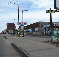
| This is Denver, not the Bay Area, but one basic issue is the same: each driveway or mid-block curb cut is a lapse in security for a pedestrian. How many other walkable street mistakes can you find? Image courtesy of Flickr user Complete Streets. |
It is an urban planning mantra that walking and transit are flip sides of the same coin. Transit riders begin and end their trip on foot; so streets that create a secure and enjoyable pedestrian experience are an important component of eliminating car trips and reducing automobile dependence. Even motorists have to be pedestrians for a portion of their trip — which only highlights the fact that the pedestrian experience is the lowest common denominator, worthy of both investment and careful thought. Many older Bay Area neighborhoods that first came into existence around transit routes naturally get the basics right, without undue effort. These are places like our urban CBDs, and neighborhood commercial districts on the streetcar lines that once blanketed San Francisco and the inner East Bay — but also select suburban locations like the older Peninsula downtown districts that sprung up at railroad depots. By contrast, other Bay Area locales that were designed with the express purpose of catering to automobiles are pedestrian wastelands — characterized by dark, uninviting freeway overpasses; long suburban blocks punctuated by strip malls, parking lots, curb cuts; narrow, interrupted or even nonexistent sidewalks; and, generally, little to no active street environment. These latter places present the greatest challenge, and they require that a calculated planning effort be applied to create walkability out of auto-oriented design. In the summer of 2008, the title of America’s most walkable city was bestowed upon San Francisco, and many of the city’s beloved neighborhoods deserve the title. Other neighborhoods — the long, bland industrial blocks and wide traffic sewers South of Market come immediately to mind — do not, although citywide blueprints for active and complete streets are a work in progress.
A vigorous debate has unfolded in the past few weeks over infrastructure spending in the federal stimulus package. Transit advocates, frustrated by the less-than-stellar past eight years, desperately seek any sign that our urban (for a change) President-Elect will effect a policy shift by robustly allocating the promised funding to transit projects — only to be disappointed by Obama’s repetitious chant favoring the expansion of roads and bridges. The conversation is, as usual, one that zeroes in on automobiles and mass transit, pitting them against each other. Less discussion has been devoted to infrastructure for a less glamorous form of transportation: walking. But a healthy, successful city is comprised of healthy, successful streets; and a high-quality, walkable street environment is the underlying link that unifies the transit and density discussion. In recognition of this truth, the Congress for the New Urbanism sent a proposal to James Oberstar, chair of the House Transportation and Infrastructure Committee, who has already been receptive to devoting more stimulus money to transit. The CNU proposal advocates for a well-rounded use of the stimulus funds, focusing on network connectivity rather than individual corridor projects. Under the proposal, some portion of a city that has 150 intersections per square mile would qualify as a “network,” which means it would be eligible to receive federal stimulus funds — not to widen a freeway or to improve transit in a particular corridor, but to transform all streets in the designated network area into green, livable streets. These streets would be upgraded in accordance with good urban design principles, in order to enhance the pedestrian experience and increase transit ridership. The multimodal vision is similar to that embraced by California’s Complete Streets Act passed this year, but it would translate into more immediate results.
We cannot help but to admire both the simplicity and the creativity of CNU’s proposal. What makes the proposal so attractive is its grounding in sound urbanist principles. The CNU proposal leverages the power inherent in a street grid to disperse traffic throughout an open, integrated network of routes. This is preferable to funneling a high volume of cars onto a few wide arteries, which encourages many drivers to use the exact same route. As a result, these wide arteries attract congestion like a magnet, and when the roadway reaches capacity, there is the perception that it must be widened to further increase capacity, leading to a vicious cycle of induced demand. This is not just a transportation and environmental problem; it is also an economic problem. Businesses are generally not located on freeways and expressways; rather, they are located on city streets. Drivers that speed through a city via freeway or other wide arterial will have little to no contact with the actual city, and thus have fewer opportunities to enjoy and contribute to the prosperity of the city by patronizing its businesses. This pattern has led to the decline of many once-prosperous urban districts and corridors, including here in the Bay Area. It confirms our observation that the freeway/artery model is inferior to the grid model, in which traffic is dispersed throughout a network of streets. But shovel-ready freeway expansions are an unfortunately prevalent item appearing on state wish lists, and going forward with a road-centered stimulus based on such projects will bring the United States even more squarely in line with the undesirable freeway/artery traffic model.
City streets, unlike freeways, naturally support a variety of transportation modes; and they can support those modes even better if we implement complete street design principles that calm traffic, and prioritize a high-quality pedestrian streetscape above moving cars faster. By proposing that intersection-dense street networks qualify as a single project unit for the purposes of stimulus funding, CNU’s proposal shifts investment away from freeways and toward our nation’s neglected city centers. Under the proposal, any street in a qualifying network could be enhanced with stimulus money. Note that this does involve spending money on the roads themselves. Roads should be kept in good working condition. Given that some money must be spent on road networks, it is preferable to invest in city streets, because funds can be applied both to repaving and to creating complete streets that are friendly and accessible to all users no matter their travel mode. The result will be increased concentration of human and economic activity in our cities — in the exact areas where trips are generally shorter, and where it is often easier to walk, bike, or take transit than it is to drive. And as noted above, a high-quality pedestrian experience is absolutely central to the success of this vision. Attractive, walkable, complete streets encourage people to shift to other modes and reduce their automobile usage, and they carry great economic benefits for cities. But even more fundamentally, they form the basic infrastructure needed for effective circulation — and to ensure that our streets retain plentiful non-automotive capacity that will accommodate future growth.
This is not to say that it is not critical to maximize the stimulus money that goes toward transit — it certainly is. But the elegance of CNU’s proposal is that moves beyond the roads-versus-transit struggle that has dominated the stimulus conversation, by emphasizing that a sensibly-crafted road stimulus can nonetheless resonate with the objectives of a transit-focused stimulus, while still improving road infrastructure. The proposal concedes that there are benefits to road construction projects — but it calls for the right type of road infrastructure investment in the right places, by leveraging the energy, vitality and efficiency inherent in cities’ street grids. If you like CNU’s proposal, you might consider getting in touch with your Congressional representative and encouraging them to integrate the CNU network designation into the stimulus package. And while you’re at it, please add your voice in support of Transportation for America, which has been taking a leading role on our behalf in pressing Congress to adopt a sustainable stimulus.


Just wrote to Ms. Pelosi!
Thanks for bringing this up, your argument is articulated perfectly.
Posted by Josh | 8 January 2009, 1:17 pmLiving near one freeway ramp (Cesar Chavez) and working near another (Harrison and 1st) may be cruel and unusual punishment, but it also provides frequent opportunities for observation.
One phenomenon always puzzled me. Bay Bridge onramps and the streets leading up to them could be utterly gridlocked, nothing moving through several light changes, while traffic a few blocks away, though still heavy at rush hour, would flow. Traffic in the Financial District or around Union Square that was completely balled up during a Critical Mass ride would have started moving again a short time later when the Mass passed again or individual riders peeled off and doubled back.
How could this be? Shouldn’t the mighty multilane freeway have the advantage over cramped multiuse city streets?
The explanation came from an unexpected source. Ivor van Heerden is the deputy director of the Louisiana State University Hurricane Center and author of The Storm, What Went Wrong During Hurricane Katrina—The Inside Story From One Louisiana Scientist, a damning account of the levee failures in New Orleans. He happened to be giving a lecture to coincide with the book release in spring 2005 when I was volunteering in New Orleans with the Common Ground Collective, and my partner and I went.
In the middle of a blistering account of the incompetence of the Army Corps of Engineers, FEMA, the White House, and so on, van Heerden asserted that some levee failure was largely the fault of Mister Go. The New Orleanians filling the auditorium nodded knowingly, while the two dumb-ass San Franciscans stared at each other and asked, “Mister WHO?”
Mister Go is the local nickname for the Mississippi River–Gulf Outlet (MR-GO), a channel dug in 1965 to connect the Intercoastal Waterway that flows through New Orleans to the Gulf of Mexico, lopping off 40 twisty miles down the lower Mississippi. It’s known in the Crescent City as an expensive, environmentally disastrous boondoggle.
The argument van Heerden made, complete with maps and diagrams of storm surge heights and wind directions, showed how the high water driven by Katrina was concentrated at the eastern end of Mister Go and its force amplified by the narrow, deep channel that sent the water rushing west toward the city, with devastating impact on the levees. Meanwhile, miles of wetlands and barrier islands that in the past had absorbed and dispersed such storm surges had been destroyed by oil and gas exploration and development. Their beneficial effect was gone.
Suddenly, it hit me. Storm surge equals heavy traffic, Mister Go equals freeway, wetlands equals city streets. The analogy is a bit far-fetched, but it’s stood up to subsequent observation. Concentrating traffic on freeways doesn’t remove it from city streets; it just amplifies the impact in certain locations. Communities near freeway ramps know the argument that freeways help reduce traffic is garbage. Cars don’t drop onto freeways from helicopters. They clog up the ramps and spread the mess back from there.
Posted by Fran Taylor | 8 January 2009, 4:23 pmoops, should be spring 2006!
Posted by Fran Taylor | 8 January 2009, 4:31 pmHallelujah!
Now when can we start tearing them down?
Posted by Josh | 9 January 2009, 1:38 pm