If you haven’t gotten to it already, please read the introductory post. Also, click here for the East Bay half of the map, which has now been posted.
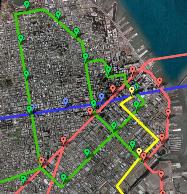
This first post will cover the San Francisco half of the subway dream; tomorrow’s post will address the East Bay half. In the introductory post, I stated sort of generally that this is a thought exercise in what could have been, rather than what should be, at least in terms of the modern climate for funding transit expansion. That said, some of the recommendations here are simply upgrades to existing infrastructure that should be carried out, as they provide improvement at a cost lower than that required to fashion new subway tunnels. First, the maps. The map on the left is the citywide map, while the right map is a focus on the northeast quadrant. For full-size versions of both maps, click the image, and you’ll be redirected to my Flickr account:
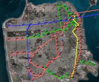
Satellite views courtesy Google Maps.
Existing BART and Muni Metro infrastructure is pictured in red; new BART infrastructure is marked in blue, and new Muni infrastructure is in green. Stations are marked with the pinmarks. Yellow represents the Caltrain corridor; here, I’ve assumed that the line has been extended beyond its current terminus at 4th/Townsend to a newly reconstructed Transbay Transit Center. Tracks would transition underground before reaching 4th/Townsend, and the current depot would be refashioned into a subway station. Trains would tunnel north underneath Second Street to reach Transbay.
As I mentioned earlier, some of the recommendations here involve upgrades to the current system. A few infill stations have been added: a Muni Metro station between Van Ness and Church, at Octavia, to serve a neighborhood that is being reborn since the freeway destruction. In addition, new stations have been added to fill in gaps on the BART line, at 20th Street/Mission and 30th Street/Mission. Balboa Park Station, which is marked in green on the citywide map, is another upgrade. This station is an important transit nexus, but connections between BART and Muni Metro are currently counterintuitive and haphazard; ideally, this would be refurbished into a more multimodal station to serve a neighborhood which is already transit-oriented, but which will hopefully be even denser and more livable in the future. Although the K-Ingleside, L-Taraval, and M-Ocean View lines are marked in red, upgrades would also be carried out on those lines: cutting out a number of intermediate stops, and eliminating or at least reducing sections in which trains are forced to operate in mixed flow with automobiles. The N-Judah, however, has its middle section marked in green. Under this subway dream, the N-Judah would remain in a subway tunnel all the way to the Outer Sunset, providing direct service to popular neighborhoods it just misses under the current configuration. After Van Ness, trains would run under Haight Street, with stops at the Lower Haight and the Upper Haight neighborhoods, before turning to serve Cole Valley, UCSF Parnassus, and the Inner Sunset (9th/Irving) — these latter three would also be underground stops. The N-Judah is very often delayed while negotiating traffic in this section of the line; relocating the tracks underground would eliminate these bottlenecks and increase reliability. Then, rather than turning onto Judah, trains would remain under Irving and stop at 19th Avenue, providing direct service to the commercial district along Irving. Trains would then resurface after 19th Avenue.
New Muni Metro infrastructure has been added to the City’s southeastern districts: a spur off the T-Third line to serve any future developments in Hunters Point, along with a direct rail connection along Geneva and through Visitacion Valley between Balboa Park and Bayshore Caltrain station (which would also receive T-Third service once the current line is extended past Sunnydale). Quite a bit of new tunneling has been added in the northeast quadrant as well. A downtown loop would enhance connections between the Financial District and the downtown-adjacent neighborhoods both north and south of Market. A new station has been added to provide direct service to Jackson Square and the north side of the Financial District, and a tunnel under Van Ness has been added to improve service in that corridor. The loop travels under Folsom Street, in anticipation of large-scale development South of Market, and would connect to the Central Subway at 4th Street (Moscone Station), and then serve a new Rincon Hill neighborhood center along Folsom before terminating at the Transbay Transit Center.
Although there’s nothing dreamy about the Central Subway, I’ve included it on this dream map in any case, since it doesn’t seem likely we can stop it, but as you see in this map, it does sort of get in the way. The fact that there will be a Stockton alignment (instead of an at least partially sensible tunnel under Kearny) forces another awkward transfer with the new Geary BART tunnel on this map. The tunnel would approach the city from the East Bay via a second transbay tube (see the upcoming East Bay map to see the possible corridors where these trains might be coming from) and stop first at the new Transbay Transit Center. Trains would then proceed under Market Street and a stop at a station near Kearny. This station would connect to Montgomery via an underground pedestrian tunnel and would also extend westward to create a forced connection to the Central Subway’s Union Square station under Stockton. (An interesting factoid: this would create quite the chain of underground pedestrian connections. A connection from Powell to Union Square is planned for the Central Subway, and under this map, Union Square would be connected to the new BART station at Kearny, which would in turn be connected to Montgomery. And Montgomery itself could be connected to the Transbay Transit Center via another pedestrian tunnel.)
The Kearny station is admittedly a halfway attempt to connect to both the Central Subway and the existing BART tunnel, while still serving Union Square. After that, trains would continue in the tunnel, serving neighborhoods along Geary: the Tenderloin, Van Ness, Japantown, the Fillmore, and the Richmond District. Stations would be placed at Jones, Van Ness (with a transfer to the Muni Metro tunnel), Fillmore, Masonic, Arguello, and Park Presidio. At this point, there would be a split. While a few trains would serve the remainder of Geary, most would turn southward, stopping at Golden Gate Park, Irving (making a connection to the new N-Judah station at 19th/Irving), Taraval (connecting to the L-Taraval), San Francisco State (connecting to the M-Ocean View), and then terminating at Daly City, or perhaps proceeding south to the Peninsula. Another possibility, not included in this map, would be to extend the 19th Avenue line north to the Presidio and the Marina as a connection for North Bay commuters — although the reason I didn’t include better service to this section of the city in general is concern about ridership.
Observant readers will notice that there are a few blanks in this map: namely, the west side of the Sunset, and the region between the BART line under Mission Street and the T-Third line. As the Third Street corridor and central waterfront become more densely developed, it will become increasingly necessary to develop strong crosstown connections between Mission Bay, Third Street, Potrero Hill, and the Mission District. The assumption here, though, is that bus rapid transit would facilitate these connections, in addition to providing improved service along the 9-San Bruno and 29-Sunset corridors. In fact, there are other opportunities for bus rapid transit which have not been marked here, but which would complement the rail network.
Check back later for the East Bay dream subway!


Great map. How come no love for the Union Street/Marina area? Perhaps its too shallow and earthquake prone. The thing I like most about this is a line under SOMA. It’s an area that could easily densify under the right conditions and has a lot of destinations. Very cool. Look forward to Oakland.
Posted by The Overhead Wire | 20 December 2007, 1:29 amI knew someone would point out the Marina/Cow Hollow gap; actually, someone else on Flickr also asked about that. My personal feelings about that section of the city aside, in the end, it just came down to another pesky reality check: the 30 and 45 bus lines aren’t crowded west of North Beach. Overlooking that, I guess it would be easy enough to extend this into the Marina, particularly if the northern section of the downtown loop were on the surface, rather than subway (as it probably would be). Incidentally, I was assuming a BRT corridor to serve that section of the city and to connect to the downtown loop.
Posted by Eric | 20 December 2007, 1:41 amThats interesting because a friend of mine who lives in the Marina says that she can’t get a seat on the 30x most of the time to downtown. Also, don’t forget the streetcar extension through the Fort Mason Tunnel. That might be the answer there to that issue although the F line is super crowded all the time.
Posted by The Overhead Wire | 20 December 2007, 1:59 amWell done Eric. How many blocks are there b/w these stops – its hard to get a sense of scale for someone not all that familiar with SF.
Posted by Doug | 20 December 2007, 8:54 amThere should be a green line spur down lombard to Lucas arts in the Presidio….
Posted by Andy | 20 December 2007, 11:00 am@ Overhead Wire: I have also heard that the 30X is crowded, but I haven’t ridden it myself. As far as I’ve noticed, though, all other service to the Marina is fairly low-demand. An F extension might be just the fix. The F is crowded, but if you have this downtown loop in place, it would be an easy transfer.
@ Andy: Certainly possible, and some people seem unhappy with the lack of a Marina line. It would be an easy enough (surface) extension, but I’m not sure if it would be well-used outside of peak hours, and the transfer doesn’t even really seem worth it for North Bay commuters over just staying on a ferry, or transferring to the downtown loop as pictured.
@ Doug: stop distances are generally about every 7 blocks, or the equivalent. Distances may vary in order to facilitate a transfer to a perpendicular line. There are a couple stretches on the west side that are further apart, because that area is less dense, with not much plan to get any denser.
Posted by Eric | 20 December 2007, 11:02 ami’m guessing a lot of commuters take the 30/41/45 to and from the financial district on workdays. but other than commuters, yes, those lines aren’t very busy past russian hill.
a subway line along lombard could possibly replace both lines.
Posted by yao | 20 December 2007, 11:40 amnice! For the westside, how about station at Geary 36th, 19th Ave (halfway b/w Judah and Taraval). And, if we are thinking big, maybe some kind of north/south line along or under Sunset Blvd from Stonestown to Geary.
Posted by shane | 20 December 2007, 1:22 pmHi Shane,
Actually, another version of this map did have exactly that; a halfway point at Noriega, and another around 36th/Geary. My reason for excluding them here is lower densities in this section of the city and no plan to increase them, and limiting stations here to key transfer points. Even with those gaps, the distance between stops is no worse than BART is already doing, but you could certainly make a case for having stops there.
This is a somewhat more “minimal” dream version, hemmed in (slightly) by a balance of cost and ridership concerns, so I’ve assumed certain areas (as you mention, Sunset Blvd, but also the Marina, Fillmore/16th Street, and the San Bruno corridor) would receive BRT treatment and service increases, instead of rail. The idea there is to have BRT sort of “fill in the blanks.” In an all-out dream map, I guess you’d just have trains everywhere.
Posted by Eric | 20 December 2007, 1:35 pmAny plan to do a Penisula Map? I think the Penisula has so much potential for good public transportation already. All they need is to convert Caltrain to a metro-type system. I can’t help noticing how many of the lines in SF are already there (N,J,K,L,M) but they currently run more like buses (or even slower than buses) than light rail/rapid transit. Too bad Muni doesn’t seem to have a plan for upgrading the older part of the Metro System. Have you reduced the stops on the Muni Metro Lines in your map? Because I see the L and N lines only have 3 stops west of 19th.
Posted by FS77 | 20 December 2007, 2:00 pm@ FS77: I wasn’t planning on a Peninsula map, because I wouldn’t really add new lines there. Caltrain should definitely be electrified so that it can provide more robust service, but the map probably wouldn’t look different, except for the Dumbarton rail crossing.
For the older Metro lines: the N-Judah is the only one I’ve marked as getting a big infrastructure upgrade, but yes, on the surface sections of all these lines, stops would be eliminated (although maybe a couple more could be added beyond what’s here) to speed up the service.
Posted by Eric | 20 December 2007, 2:54 pm19th Avenue could certainly use an upgrade over the pathetic 28 line. It serves SF State and is a straight shot for the west side of the city to get to Daly City BART and SFO.
However, getting the State of California to do anything about 19th Avenue is another story. How many years has it taken to get merely a promise to upgrade the traffic signals on 19th? More substantial improvements would likely meet with more substantial resistance.
Posted by seven | 20 December 2007, 3:35 pmIf you have any further interest in fantasy subway maps, check out getlamoving.com
I know, I know, this is a subway map for the Los Angeles area, but it’s a doozy. Even more extensive than this one. Might be instructive in pitching fantasy lines to the public.
Or, just fun to look at.
Posted by Scott Mercer | 21 December 2007, 8:17 amI think you do need another stop on Geary, probably around 36th. The Outer Richmond is MUCH more dense than most people realize – take a look at ridership out there for all of the 38, 31, 1, 2 and 5 lines (a Geary subway may not draw much away from the 5, but all of those other lines would be massacred in the Outer Richmond by a Geary subway – if stops were available)
Also, I don’t think you’d want most trains not heading out there – probably more of a 50/50 split.
Posted by Chris | 21 December 2007, 2:07 pm@ Scott: thanks, I have seen that link. Looking at that map, without paying attention to station names, or the fact it’s a fantasy, you would think you’re in another country.
@ Chris: You know, that 36th/Geary stop has sort of dropped in and out on different versions of it — not because I don’t like it, but more because I wonder whether or not it would actually be put in if this line were built. Incidentally, the same is true of the 19th/Noriega stop. Then again, maybe I shouldn’t be worried about that, in a true dream.
Posted by Eric | 21 December 2007, 4:28 pmEric,
I have to assume that if there isn’t a 36th St stop, it would be because there is no line going out that far. I can’t imagine a scenario where we build a subway to the ocean but don’t have any stops between 25th and 48th. Perhaps if the line’s last stop on Geary is at Park Presidio?
Posted by Chris | 21 December 2007, 7:42 pmChris – I agree that the population density of the Richmond is surprisingly high. I’d guess its quite a bit higher than in the Sunset. Too many ‘Richmond specials’ I guess. This all may be a dream, but in time (50 years?) who knows.
Posted by Eric Phillips | 21 December 2007, 7:55 pmOne compromise might be to just end it a bit earlier — maybe Park Presidio, or maybe something a bit more “central” to this last segment, like 40th.
The distance between 25th and 48th sounds high from the numbered avenues, but these are short blocks– the distance is actually about the same as that between Glen Park and Balboa Park BART stations. So, you don’t need to imagine it– we’ve already got it! Not to imply that is necessarily a model to follow, but just saying…
I don’t have exact numbers right now, but just as a point of comparison, the density of the Outer Richmond is substantially less than much of the Mission, but: Google reports the distance between 16th/Mission and 24th/Mission to be 0.9 miles, and the distance between 25th/Geary and 36th/Geary to be 0.6 miles. So, there you’ve got a denser neighborhood, with a more intense diversity of uses, but with potentially less service (though I tried to fix that by putting an infill station at 20th/Mission — which probably wouldn’t happen). In the real world, building an infill station at 30th Street has been predicated on upping TOD in the neighborhood, something which could/should happen all along Geary, but it seems like your opportunities to do so peter out in this “home stretch” of Geary by the ocean.
Despite everything from above, I’m actually not disagreeing with you (in case that wasn’t clear): certainly in terms of accessibility, there should be a stop at 36th, and as I said, other versions of this map included it. Actually, part of the reason why I didn’t put it in this map was to see if anyone would complain, so I’m glad someone has. :) But they’d be weighing all of the above and more in figuring it out, and in the end, I’m not convinced they’d come out with as many stations as we would want, especially given how expensive each additional station would be — which is part of the reason I left it off here. Putting all factors together, the compromise they might hatch would be to just end the line well before the ocean, or, worse, curve it north to the Golden Gate Bridge and then ignore the Richmond and the Sunset altogether.
Then again, BART hasn’t done any urban expansions since… well, ever. (Or at least, since Embarcadero Station.) So maybe with this line, they would (hopefully pleasantly) surprise us?
Posted by Eric | 22 December 2007, 1:21 amFair enough, Eric :)
Your comparison to the Mission is right on – but it should also be noted that the Mission is almost the most dense neighborhood served by BART currently. Nearly all of the neighborhoods that would be served by your new SF and East Bay lines would be less dense than the Mission – and most would also be substantially less dense than the Outer Richmond as well.
I would stick by my intial assessment – if we build a line past Park Presidio, it needs to have three stops. Otherwise we wouldn’t be serving a vast swath of people in the middle. I think too often the Richmond gets lumped in with the Sunset – almost every like building in the Sunset could be in the Richmond, if you added another story to the top.
Posted by Chris | 22 December 2007, 12:23 pmWell, I for one am loving on this. There are a number of things I might do differently, but the point is that Eric has put a tremendous amount of serious thought into this, and there are many, many interesting ideas here.
Let me try to back Eric up on a couple of points, substantiated by data I’ve seen:
– A few Marina express buses might fill up, but as an all-day transit market it just doesn’t merit substantial investment, even in the long term. I’ve never quite understood the Marina impulse a lot of local railfans seem to have. Ride an ordinary 30 past Stockton some time and watch what happens.
– Likewise, the Outer Richmond is much less dense than the Inner (personally, I wouldn’t go any farther west than 33rd). Same for the Sunset.
– Eric’s multimodal instincts are spot on. Realistically, some of these rail corridors could probably get by even in the long term with simple rapid bus. But the point is that there’s nothing wrong with matching investment to demand on a corridor-by-corridor basis *if* you can ensure seamless connectivity (which mind you, will probably always be a challenge in S.F.).
One thing I would add is some sort of service to (a densely redeveloped) Candlestick. BRT would work, but it also wouldn’t cost much to spur or loop from the T.
Posted by Steve | 26 December 2007, 8:53 pmOh, I should add that when I talk about modest densities, I’m also thinking of long-term development potential: Unless the Outer Richmond merchant crowd all dies off without leaving descendents, it’s hard to imagine that part of town ever being much more than it is now. And we really should not be making multibillion-dollar investments *ever* in places where we can’t expect at least *some* return on investment beyond improved service for existing residents.
Posted by Steve | 26 December 2007, 8:56 pmOne thing I would add is some sort of service to (a densely redeveloped) Candlestick.
Good point.
Unless the Outer Richmond merchant crowd all dies off without leaving descendents, it’s hard to imagine that part of town ever being much more than it is now.
In some sense, this is the crux of why 36th Ave station was left out of this map. If this map is an indication of which areas could use better transit service, it is also a map of places to add denser infill development.
Posted by Eric | 26 December 2007, 9:55 pmI agree on the points about the Outer Richmond not being open to further densification – but besides Park Merced, where is further densification going to happen along the other BART line that’s on the map under 19th? The length of line from Park Presidio to Daly City is quite a bit longer than the length would be from Park Presidio to say 40th (going with the idea of a 25th Ave and 40th Ave station) – where would higher ridership lie?
The 19th Ave line would draw riders from the 28, L, and N, with perhaps a few other lines and new riders adding to ridership (smidgen from the M as well), whereas the Geary line would draw riders from the 38, 1, 2, 31, and all of the associated X and L variations. Where would the greater increase in operational efficiency happen? (Assuming BART and Muni cared about increasing each others efficiencies, of course :))
Does neither line make sense?
Posted by Chris | 27 December 2007, 1:01 pmThe 19th line makes some sense because by connecting to the N and the L, you greatly increase capacity over the entire Westside. Which of course begs the question: without densification, do you need it? But I suspect there are many drivers on the Westside who would take BART downtown.
Posted by Steve | 29 December 2007, 3:08 pmAlso: Anything you can do to put a dent in 19th Avenue traffic is a major benefit for the neighborhood.
Posted by Steve | 29 December 2007, 3:11 pm^^^ Those reasons are basically why the 19th Ave line is there: improving the greater network, and to make a much shorter trip from the westside to downtown. You could put the Metro on 19th too, of course, but the transfer at Geary/Park Presidio makes this trip less appealing, though still a clear improvement over what we have now.
In addition, BART on 19th could at least partially redeem BART’s Peninsula extension, if 19th Ave trains continued south past Daly City. Electrified Caltrain could handle the regional trips between the Peninsula and eastside SF, while BART would cover the regional trips between the Peninsula and westside SF, in addition to providing direct connections to destinations along the L, M, and N Metro lines.
Posted by Eric | 29 December 2007, 4:16 pmGood points, and trust me – I would love to see a line down 19th. However, that’s a LONG and expensive tunnel.
It would hopefully help with traffic along 19th, but this is actually one case where something on the surface might be better – if state approval could come to take a lane in each direction for BRT or the Metro. If we do nothing to the streetscape of 19th and just add BART underneath, I can’t imagine traffic on 19th decreasing or slowing much.
Posted by Chris | 29 December 2007, 6:24 pmI would love to see a line down 19th. However, that’s a LONG and expensive tunnel.
Quite true; hopefully you’ll be happier with the BRT dream maps, which I’ll get around to posting in the new year.
Posted by Eric | 31 December 2007, 12:09 amThanks for putting this together Eric – it’s a great dream and matches pretty closely with mine :)
However, you left out the essential Treasure Island Cable Car.
Posted by Chris | 31 December 2007, 2:32 pmThanks Eric, great thinking.
I have another dream about using elevated rail systems that would work really well with these proposed routes. There is a lot of interesting precedent out there to use elegant above-the-road systems instead of subway systems. For example, everyone knows about monorails, but what about these?
http://faculty.washington.edu/jbs/itrans/aerobus.htm
Could San Francisco consider some of these alternatives? I have collected some research here to spark some innovative discussion.
http://web.mac.com/ericchaves/AirTram_Concept
I am excited to hold a short brainstorming session to see what comes out of it – let me know if anyone is interested.
Thanks, Eric
-EC
Posted by EC | 2 January 2008, 5:22 pmIt’s an interesting question. Generally speaking, elevated rail should be a consideration, since it’s a good way to provide subway-level service without the expense of tunneling. That said, San Francisco has traditionally prided itself on being a city in tune with its natural surroundings, so I have to wonder how people would react to something elevated like this, which would block views — though I bet the views from an air tram like this would be great. Streetcars running in mixed flow on the streets has been a part of the San Francisco landscape for decades, while an elevated line like this would be wholly new. It’d be fun to see how this sort of a plan would go over if proposed to residents near 40th and Judah, for an N-Judah upgrade.
For the Central Subway corridor, stopping the tunnel isn’t likely for political reasons, which unfortunately tend to be given primary consideration above transportation-related reasons, but I wish the MTA would seriously study alternatives — not tunnel alternatives, but actual alternatives. The only portion of the 30/45 corridor that really needs extra capacity is the section of Stockton between Market and Columbus — a length of just a mile. There are definitely cheaper ways to provide extra capacity over such a short distance.
Posted by Eric | 2 January 2008, 8:13 pmNice map. Very informative. Keep up the work.
Posted by irect | 12 January 2008, 6:28 pmWOW! Cool site and I’m glad to be back in SF even though riding the NYC subway for a year was amazing.
While I was away I envisioned a second transbay tube that would run BART along 4th St., up Stockton (replacing the Central Subway boondoggle), along Columbus Ave., around the Aquatic Park and down Van Ness where it would join with the current BART line on Mission. Stations would be:
4th/King (transfer to MUNI and Caltrain)
Moscone Center
Union Square/Powell (transfer to MUNI and other BART lines)
Chinatown
North Beach
Aquatic Park/Fort Mason
Union St.
California St.
Geary
City Hall
Van Ness (transfer to MUNI)
connecting to 16th/Mission BART
Across the bay the tube would serve a station in Alameda (transfer to an historic streetcar line connecting the commercial districts along Webster and Park) and Jack London Square before connecting with existing BART…honestly, I need to work on this segment because I’m not too familiar with the East Bay, not owning a car.
In addition, this second transbay tube would carry HSR/commuter rail from the east bay. Just before entering SF, the tube would split and the HSR/commuter rail segment would run along 2nd St. to the new transbay terminal, joining with an underground caltrain along the way from the south bay (as currently proposed).
Finally, a branch from the the existing BART line between Montgomery and Powell Stations will be built to serve the Geary/19th Ave. corridors. The Union Square station will connect to the new BART line on Stockton and the existing Powell St. station creating a “Times Square” sort of deal. The line will continue along Geary with the following stops in some of the highest-density areas outside of NYC (east of Van Ness):
Union Square/Powell (transfer to MUNI and other BART lines)
Leavenworth
Van Ness/Geary
Fillmore
Masonic
Arguello
Inner Richmond (somewhere near 8th or 9th Ave.)
GG Park
Judah (transfer to MUNI)
Taraval (transfer to MUNI)
Stonestown/SFSU (transfer to MUNI)
connection to Daly City line
Why BART and not MUNI?
1. The goal is to move more people faster throughout the city. Surface lines simply aren’t fast enough or equipped to handle large capacity. The 1-car train proposal for the Central Subway is a joke. A freakin’ joke.
2. The goal is to connect more neighborhoods and commercial districts. Imagine telling your spouse or friend…”Let’s take BART to the Giants game.” Or, “There are great Russian restaurants in the Richmond. Let’s jump on BART and try one of them.”
3. The goal is to get people out of their cars, even for a couple hours a week more than usual. Encourage high-density development, especially in SOMA where high-rise condo building construction should deter car ownership, not promote it. Then again, you can’t ride rail if there isn’t a viable alternative.
“Build it and they will come.” Perfect example being the mid-city Green Line when it opened in Washington, DC in 1999. 2 stations built relatively close together surpassed all ridership expectations,
Posted by sftransitjunkie | 6 February 2008, 5:11 pm