Transbay Blog
Please Note: This is a partial list of transit projects, to be fleshed out over time.
Select a transit project by Bay Area region, or scroll down further for the alphabetical listing.
California
East Bay
BART to Livermore | BART to Warm Springs | Dumbarton Rail | East Bay InTel Corridor | eBART | Oakland Airport Connector | West Dublin/Pleasanton
North Bay
Sonoma-Marin Area Rail Transit (SMART)
Peninsula
Caltrain 2025 | Dumbarton Rail
San Francisco
Caltrain 2025 | Central Subway | Downtown Extension (Caltrain/HSR) | Geary Boulevard | Transit Effectiveness Project | Van Ness Avenue
South Bay
BART to San Jose | BART to Warm Springs | Caltrain 2025 | Downtown/East Valley
—
BART to Livermore
In July 2010, the BART Board of Directors selected a preferred alignment for the long-discussed BART extension to Livermore. The extension serves downtown Livermore and the Lawrence Livermore National Laboratory, while facilitating two potential intermodal connections to upgraded intercity rail on the Altamont corridor.
(More to be added later.)
Read More:
Gearing Up for Livermore and Altamont (Part 1), 10 Nov. 2009
BART Board selects alignment for Livermore extension, 1 Jul. 2010
—
 BART to San Jose
This proposed 16-mile BART extension into Santa Clara County assumes that BART will already have been extended south of its current Fremont terminus to Warm Springs. South of Warm Springs, BART trains would connect to VTA light rail, Caltrain, Capitol Corridor, ACE, and high-speed rail, stopping at six stations: in Milpitas at Montague/Capitol, and at Berryessa; then transitioning into a subway tunnel under Santa Clara Street, stopping at three subway stations at Alum Rock, Downtown San Jose, and Diridon/Arena; and finally, resurfacing and terminating in Santa Clara. The project also includes maintenance shops and yard for BART on the site of the Union Pacific Newhall Yard. It has been a challenge to pool together the funding for this now $7.6 billion extension: 2000 Measure A sales tax funds have proven insufficient, even though VTA has directed significant funding toward BART at the expense of other transit improvements in the Valley. 2008 Measure B narrowly passed and is intended to provide supplemental operating funds, once the federal government commits to a $750 million grant for the project. Even so, VTA can only afford to construct the extension in phases. The first phase, expected to be complete in 2018, will add the Milpitas station and terminate at Berryessa — assuming that the FTA agrees to contribute money this time around.
Read More:
BART to San Jose (Volume 1): A Long-Expected Party, 1 Oct. 2008
BART to San Jose (Volume 2): The Shadow of the Past, 6 Oct. 2008
BART to San Jose (Volume 3): Wicked, Tricksy, False, 20 Oct. 2008
BART to San Jose (Volume 4): All’s Well As Ends Better, 27 Oct. 2008
No, No, No on Measures B, C, D (Santa Clara County), 1 Nov. 2008
San Jose Diridon: Grand Central or Bust, 24 Nov. 2008
From the Horse’s Mouth, 12 Dec. 2008
The March to Berryessa, 1 Mar. 2009
Shifting Funds, Shifty Priorities, 26 Mar. 2009
Record of Decision issued for BART to San Jose, 25 Jun. 2010
—
 |
| Courtesy of City of Fremont. |
BART to Warm Springs
The 5.4-mile extension south of BART’s existing Fremont terminus to Fremont’s Warm Springs District is best understood as a first phase of BART to San Jose. Indeed, part of the funding for the Warm Springs extension, whose total project cost is about $890 million, is conditioned upon full funding being available for the future extension into Santa Clara County. The extension to Warm Springs would add only one new station to the BART system, though the plans include the possibility of a future infill station in Fremont’s historic Irvington District. The tracks would align onto the Union Pacific corridor, transitioning into a subway under Stevenson Boulevard, Fremont Central Park and Lake Elizabeth; then resurfacing to pass over Paseo Padre Parkway and under Washington Boulevard; and finally terminating at the Warm Springs at-grade island platform and tailtracks. To close the longstanding funding gap for the Warm Springs extension, MTC redirected $91 million of Regional Measure 2 funds away from Dumbarton Rail — a decision that was challenged unsuccessfully in court. In the meantime, BART is moving forward with two critical pieces of infrastructure needed for the extension. Although a roughly $225 million contract was anticipated for the construction of the subway alignment, bids came in significantly lower; in May 2009 the BART Board awarded a $136 million contract to the Shimmick/Skanska joint venture for the subway portion of the project. The City of Fremont is working concurrently on grade separations, which will relocate Union Pacific freight tracks and construct an overpass, such that BART trains traveling between Fremont and Warm Springs can pass over Paseo Padre Parkway and under Washington Boulevard at grade.
Read More:
BART to San Jose (Volume 1): A Long-Expected Party, 1 Oct. 2008
Lawsuit Challenges the Warm Springs Funding Swap, 4 Mar. 2009
Preliminary Injunction Against Warm Springs Denied, 18 Mar. 2009
—
 |
| Courtesy of Newlands & Company. |
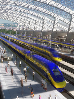
California High-Speed Rail
California High-Speed Rail is poised to become the first true high-speed rail line in the United States and a model for emerging high-speed rail corridors throughout the nation. The first phase of this project would link San Francisco’s Transbay Transit Center to Los Angeles Union Station via San Jose, the Pacheco Pass, and the Central Valley. (See also: Caltrain Downtown Extension.) The fastest high-speed trains would make the SF-LA trip in 2 hours 38 minutes, reaching a maximum speed of 220 miles per hour. The project would link most of California’s major population centers to the high-speed rail network, and later phases of the project are planned to extend the network to Sacramento and San Diego. High-speed rail will profoundly alter the notion of mobility in California, and high-speed rail stations will be natural locations to focus dense transit-oriented development throughout the state. The California High-Speed Rail Authority certified the project’s programmatic EIR and is currently preparing detailed EIRs for specific project segments; the CHSRA has further indicated that a test track will likely be constructed in the Central Valley, between Bakersfield and Merced.
An important component of project funding was jumpstarted when voters approved Proposition 1A, a bond measure that will provide $9 billion to construct the network’s spine between San Francisco and Los Angeles and $950 million to enhance feeder systems. Things are also looking up since the election of President Barack Obama, who has made high-speed a centerpiece of his transportation platform. Not only does Obama’s FY2009-10 budget allocate $5 billion to high-speed rail over five years, but the American Recovery and Reinvestment Act stimulus package included $8 billion of high-speed rail grants. California High-Speed Rail is the furthest along of all the nation’s high-speed rail projects, in terms of planning and funding, and it is likely to receive a substantial chunk of that money (although exactly how much stimulus money California will receive remains to be seen). The Bay Area will apply for a large piece of the $8 billion stimulus funding pie, including $600+ million necessary to excavate the station box at San Francisco’s Transbay Transit Center during the first phase of construction.
Read More:
Altamont Bypassed, 11 Jan. 2008
High-Speed Rail Interactive Map, 15 May 2008
AB 3034 Passes Senate Transp. and Housing Committee, 2 Jul. 2008
From AB 3034 to November 4, 9 Aug. 2008
AB 3034: The High-Speed Drama Continues, 11 Aug. 2008
Governor to Sign High-Speed Rail Bill, 26 Aug. 2008
Yes on Proposition 1A (High-Speed Rail), 30 Oct. 2008
Stimulus Update: Details from the Final Package, 12 Feb. 2009
Regional Proposal for Bay Area Transportation Stimulus, 23 Feb. 2009
TJPA Considers CHSRA Requirements for the Transbay Terminal, 12 Mar. 2009
Obama Administration Unveils HSR Strategic Plan, 17 Apr. 2009
Open Thread and Early May News Roundup, 6 May 2009
BACEI Releases Workplan, 9 Jun. 2009
Peninsula Investments, 17 Jun. 2009
Trans-Beale Terminal, 11 Sept. 2009
—

Caltrain 2025
In 2004, Caltrain fleshed out its service by adding to the daily mix several peak hour Baby Bullet trains that made the trip between San Francisco and San Jose Diridon stations in just under one hour. Ridership has soared since this service expansion — and although Caltrain’s large off-peak headways (60 minutes, midday and weekends) reinforce the notion that Caltrain is merely an antiquated railroad fashioned for commuter use, this railroad is poised to shed its skin and emerge as something akin to frequent, rapid transit for the Peninsula. The corridor overseen by the Joint Powers Board will be radically transformed in the next two decades by the construction of California High-Speed Rail, whose trains will use the Caltrain corridor between San Jose Diridon station and San Francisco’s Transbay Transit Center, and Caltrain service stands to benefit from the upgrades. Long double-tracked stretches will be replaced with four tracks, and at-grade street crossings will refashioned into grade separations. After compounded delays, Caltrain’s diesel service will at long last be electrified (its current rolling stock to be replaced by lightweight electric multiple units), and Caltrain will implement a new signaling system with positive train control by 2015, in compliance with federal requirements. These changes will increase ridership by improving ride quality, and by bringing more stations into the fold of faster express service. Caltrain will also be able to accommodate up to three times the ridership than currently possible, thus allowing it to realize its full potential — as not merely a commuter railroad, but as a critical link in the regional rail network.
Read More:
Celebrating a Milestone and Biding Time, 7 Aug. 2008
Peninsula Investments, 17 Jun. 2009
It was the best of times, it was the worst of times, 5 Apr. 2010
—

Courtesy of SFMTA.
Central Subway
In April 2007, revenue service began on the T-Third Street line, the first expansion of San Francisco’s Muni Metro light rail system in approximately a decade. The 5.6-mile extension south of the N-Judah terminal at 4th and King carried a promise of change for oft-forgotten waterfront neighborhoods both emerging and established, including Mission Bay, Dogpatch, the Bayview, and Visitacion Valley. The second phase of the T-Third line is the Central Subway, a $1.6-billion project that is now believed will open in the year 2018. The subway has been harshly criticized by Transbay Blog and other transit advocates, for providing limited benefit at astronomical cost. Like the initial operating segment of the T-Third line, it has suffered from inexpert planning and engineering, but despite its flaws, the project has received a medium-high rating from the FTA. The extension is planned to follow a 1.7-mile route along 4th and Stockton Streets. Instead of traveling along the Embarcadero and under Market Street, as they do now, T-Third trains would travel north on 4th Street, stopping at surface station at Brannan before diving into a subway tunnel whose portal will be built under Interstate 80. Trains would stop next at a subway station at Moscone (4th & Folsom), and then burrow deep under the two-level BART/Muni Market Street subway to stop at the Union Square/Market Street station, which would have a pedestrian connection to the existing Powell Station. Trains would then travel north under Stockton Street, terminating at Chinatown Station, which would be between Washington and Jackson. The deep tunnel will be constructed with tunnel-boring machines that will be daylighted near Washington Square. The fact that the utility of the Central Subway is limited by its short length — and the fact that the daylighting of the TBMs would occur at Washington Square, the most natural location for a North Beach station — has prompted a push for a third phase of the T-Third, outside the scope of the federal matching funds anticipated for the current incarnation of the project, which would provide revenue service only as far as Chinatown. One proposed extension would extend the line north along Columbus Avenue to Fisherman’s Wharf, where trains could connect to buses using a rapid transitway on Van Ness Avenue; other proposals, such as a recent suggestion by Supervisor Alioto-Pier, would extend the line even further to the Presidio.
Read More:
Central Subway: An Introduction, 13 Nov. 2007
Central Subway: Alternative Alignments, 14 Nov. 2007
Central Subway: Stations, 15 Nov. 2007
Central Subway: Visionary Project or Colossal Boondoggle?, 16 Nov. 2007
Central Subway: Thinking Outside the (Station) Box, 18 Nov. 2007
MTA Board Selects Central Subway Alignment, 19 Feb. 2008
Board of Supervisors Certifies Central Subway EIR, 17 Sept. 2008
The Northwest Subway, 18 Mar. 2009
—
Downtown/East Valley
Coming soon.
—
Downtown Extension (Caltrain & High-Speed Rail) to Transbay Transit Center
Coming soon.
Read More:
Regional Proposal for Bay Area Transportation Stimulus, 23 Feb. 2009
TJPA Considers CHSRA Requirements for the Transbay Terminal, 12 Mar. 2009
BACEI Releases Workplan, 9 Jun. 2009
Peninsula Investments, 17 Jun. 2009
Trans-Beale Terminal, 11 Sept. 2009
—
 |
| Courtesy of BayRail Alliance. |
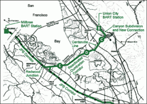
Dumbarton Rail
Dumbarton Rail is an east-west transbay commuter rail corridor that would rehabilitate the old rail trestle just to the south of and parallel to the Dumbarton Bridge. Twelve daily trains would link the Caltrain corridor on the Peninsula to southern Alameda County, serving four stations: Willow Road in Menlo Park, Willow Street in Newark, Fremont Centerville Station, and a planned intermodal station in Union City. Dumbarton Rail would connect various regional rail operators that are currently disconnected: Caltrain, Capitol Corridor, Altamont Commuter Express, and BART. It would also take pressure off of BART’s heavily traveled Transbay Tube, by providing a second transbay rail connection. However, MTC transferred $91 million of Regional Measure 2 funds from Dumbarton Rail in order to close the funding gap for BART to Warm Springs. Replacement funding for Dumbarton is only expected to materialize between 2019 and 2027, thus indefinitely postponing this project. A lawsuit was filed challenging the defunding of Dumbarton Rail, but then later dropped. BART has since moved forward with the Warm Springs extension.
Read More:
Lawsuit Challenges the Warm Springs Funding Swap, 4 Mar. 2009
Preliminary Injunction Against Warm Springs Denied, 18 Mar. 2009
—
 |
| Courtesy of AC Transit. |
East Bay InTel Corridor — Telegraph Avenue/East 14th Street (BRT)
AC Transit has already launched two “rapid bus” routes, the 1R and the 72R — but despite their names, both of these “rapid” routes are really limited buses with special branding. Although sometimes mistakenly referred to as bus rapid transit, these two corridors do not have dedicated lanes, which is the hallmark feature of BRT — but they do feature widely spaced stops and signal priority, so they reflect at least an incremental (and quite noticeable) improvement over local service. During the same time period, AC Transit has also moved forward with planning and environmental review for a bona fide BRT project, with dedicated lanes planned along most of the 1R corridor (along with other expected features, like more comfortable stations with ticket machines). The process has not been entirely smooth, and the project has encountered vocal opposition, particularly in Berkeley (although, in November 2008, the majority of Berkeley citizens voted against a NIMBY voter initiative that would have significantly delayed the BRT project). BRT will mirror the current 1/1R corridor, running from downtown Berkeley to San Leandro, along the way serving Telegraph Avenue, Downtown Oakland, and East 14th Street. The 1 and 1R services combined constitute AC Transit’s busiest route, used by over 20,000 daily riders: a number which, of course, is projected to substantially increase following BRT rollout.
Read More:
East Bay BRT Hits Snag at Lake Merritt, 6 Feb. 2008
Rapid Bus Minus, 19 May 2008
Not Everyone in the East Bay Hates BRT, 12 Jun. 2008
City of Berkeley v. Voters of Berkeley Averted, 8 Jul. 2008
Berkeley BRT Ballot Initiative City Council Update, 8 Jul. 2008
No on Measure KK (Berkeley), 3 Nov. 2008
Whither East Bay BRT?, 26 Sep. 2009
—
eBART
Coming soon.
Read More:
April 2009 BART Budget and Project Updates, 22 Apr. 2009
—
 |
| Courtesy of SFCTA. |
Geary Boulevard (BRT)
Geary, perhaps more than any other transit corridor in San Francisco, calls out for improved transit service. Over 55,000 daily riders use the local, limited, and express buses that serve Geary, making it the busiest bus line in the western United States. Plans to improve transit on Geary once called for a surface light rail running in the median of Geary Boulevard that would transition into downtown subway east of Laguna Street; that subway tunnel would have had a physical connection to the Central Subway at a shared Union Square station. But any plans to recreate the B-Geary streetcar of old as a new Muni Metro line have been postponed or abandoned, replaced instead by a $150-$200 million bus rapid transit project. Other than the specific design challenges posed by the intersections of Geary Boulevard with Fillmore and Masonic, the plan for Geary BRT resembles its sister BRT project on Van Ness. Unlike the Van Ness BRT project, though, there is discussion of making Geary BRT rail-ready, built to the physical specifications that would permit the median bus-only lanes to be converted to track for light rail — even while there is no discussion of actually taking the next step toward rail. East of Gough Street, Geary buses would be given transit preferential treatment (but not dedicated lanes) for the clogged downtown section of the route, forming the weakest link that may ultimately determine the line’s reliability. West of Gough, the project will feature dedicated lanes, signal priority, and stations with ticket machines and Proof of Payment. Stations have not yet been determined, but they would most likely be located at major transfer points along the route, where the 38L-Geary Limited bus now stops.
Read More:
A Tale of Geary Street, 20 Aug. 2008
SFCTA Moves Forward With Geary BRT Alternatives, 6 May 2009
—
Oakland Airport Connector
Coming soon.
Read More:
Regional Proposal for Bay Area Transportation Stimulus, 23 Feb. 2009
April 2009 BART Budget and Project Updates, 22 Apr. 2009
Disconnect the Connector, 21 Jul. 2009
Catch a TIGER by the Toe, 4 Aug. 2009
Is the Oakland Airport Connector a Good TIGER-TIFIA Project? (Part 1), 13 Aug. 2009
Is the Oakland Airport Connector a Good TIGER-TIFIA Project? (Part 2), 18 Aug. 2009
Complaint Filed with the FTA Against the OAC, 4 Sept. 2009
—
Sonoma-Marin Area Rail Transit (SMART)
Coming soon.
Read More:
A SMART Pipe Dream, 2 Jul. 2008
Yes on Measure Q (Sonoma & Marin Counties), 3 Nov. 2008
—
 Transit Effectiveness Project
The San Francisco Municipal Railway has the dubious distinction of being one of the the nation’s slowest transit operators. Its buses, light rail vehicles, streetcars, and cable cars crawl through city streets at an average of 8 miles per hour. On especially congested downtown streets, a mobile person can keep up with or even outpace the bus relatively easily, just by walking. Moreover, despite voters mandating that the system run 85% on-time, on-time rates have remained stuck within a couple percentage points of 70%. This means that reliability and speed are among riders’ primary complaints, and while some of the blame can be safely placed on the SFMTA itself, one major component of the problem is that transit vehicles are given no or limited priority on city streets, forcing them to contend with private automobiles and traffic congestion. There is no single route run by Muni that has its own dedicated right-of-way for the entire length of the line (except the S-Castro Shuttle, where S stands for Sporadic). Dedicated rights-of-way, whether for bus or rail, are a long-term goal for Muni’s busiest lines — about a dozen rail and bus lines, which carry 75% of its daily ridership. Building those dedicated transitways will require a great deal of time and money, and efforts to improve certain important corridors identified in the 1995 Four Corridors Plan have been underway (see: Central Subway, Geary BRT, and Van Ness BRT).
For now, the SFMTA has pursued the Transit Effectiveness Project, which recommends incremental, short-term improvements to carry the system through the next five years. The recommendations are based on hard data that clarify how riders use the system. The main principle driving the TEP is to shift resources away from less popular routes to increase frequency on the most popular “rapid network” routes — and, in particular, to augment the limited buses, which would expand a desirable service, speed up many runs, increase system efficiency, and boost ridership. The plan has proven quite controversial — unsurprising in a town where even removing a few bus stops can create fierce opposition — but the initial draft of route changes substantially improved once the community became engaged in the process. The TEP has stalled for awhile due a to collapsing budget. The SFMTA has recently been able to take advantage of the extensive data collected in the TEP’s first phrase to inform the service cuts and changes it will implement in connection with balancing the budget, but the TEP’s suggested service increases have been put on hold. And as for controversial removal of bus stops? Since the release of an SFMTA study suggesting that 70% of the city’s bus stops are spaced too close together, even that is now on the table.
Read More:
Good News for Mission Street, 3 Feb. 2008
SFTEP: Proposed Route Changes, 26 Feb. 2008
Have Your Say on the Transit Effectiveness Project, 30 Apr. 2008
Pushing the TEP Envelope, 14 May 2008
SFTEP: Fall 2008 Route Revisions, 15 Sep. 2008
SFTEP Moves Forward to Environmental Assessment, 21 Oct. 2008
—
 |
| Courtesy of SFCTA. |
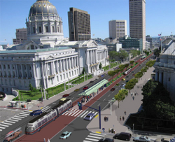
Van Ness Avenue (BRT)
Van Ness Avenue, also known as Highway 101, is not just major automotive thoroughfare — it is also one of San Francisco’s primary transit corridors. Van Ness is currently served by the 47-Van Ness and 49-Van Ness/Mission buses, which carry 40,000 daily riders, and an occasional short-line bus that terminates at Market Street. Riders on Van Ness contend with slow travel times; crowded, jerky buses; and sporadic service highly subject to bus bunching. The $120 million Van Ness bus rapid transit project would feature two miles of dedicated bus lanes along Van Ness, running from Lombard to Mission, with BRT stations falling every few blocks, at major transfer points. The dedicated lanes — combined with signal priority, low-floor buses, stations with ticket machines and Proof of Payment, and pedestrian improvements — would decrease travel times and improve ride quality; it would also help to transform Van Ness Avenue into a greater street than it is now. Reliability will be improved, but it is worth bearing in mind that BRT is no magic bullet: the 47 and 49 “rapid” lines would continue to compete with automotive traffic for the remainder of their routes, outside of the Van Ness transitway. The project still awaits full funding and environmental review, but BRT service could begin by 2013.
Read More:
Van Ness BRT: Why We Need It, 8 Oct. 2007
Van Ness BRT: Design Alternatives, 8 Oct. 2007
Van Ness BRT: Service Plans, 8 Oct. 2007
—
 |
| Courtesy of BART. |
West Dublin/Pleasanton Infill Station
West Dublin/Pleasanton is an infill BART station currently under construction in the segment of BART track in the Interstate 580 median and is anticipated to complete construction later in 2009; it fills in the uninterrupted ten-mile gap between Castro Valley station and terminal at (East) Dublin/Pleasanton. The $80 million station is projected to have about 6,000 daily entries and exits immediately after opening, increasing to about 8,600 within five years. The station includes about 1,200 parking stalls and is planned to be surrounded by transit-oriented development, including retail space, hotel rooms, and several hundred new homes — but development at the station is currently stalled pending the financial crisis.
Subscribe


Links

If you are interested in California water issues, you may want to check out my other blog on that topic.
Copyright © 2007-2021 Transbay Blog.


Comments are closed.