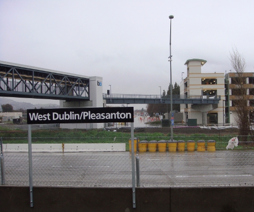
On February 19, 2011, BART officially opened the 44th station in its system: The West Dublin/Pleasanton station, a $106 million project that bridges the long 10-mile gap between the Dublin/Pleasanton terminus and Castro Valley. Like Dublin/Pleasanton, its sibling station 1.5 miles to the east, West Dublin/Pleasanton was built in the median of Interstate 580. Pedestrian bridges connect the station to parking garages on each side of the freeway, and they can also function as a new path providing pedestrian access between Dublin and Pleasanton over the freeway. The new station was included in the original EIR for the Dublin/Pleasanton extension, certified by the BART Board of Directors in 1990. The station was postponed, however, and the extension opened in 1997 without it. An agreement was later negotiated to finance the station with a mixture of public and private funds. Construction of the station finally commenced in 2006, but the planned opening date was delayed a year when it was determined that the pedestrian bridge welds were unsafe.
BART’s press release and some news reports describe West Dublin/Pleasanton as the first “infill” station since Embarcadero opened in 1976 — in the sense that the station was built along existing track, rather than by the usual procedure of extending track and creating a new terminus. While it does fit the technical definition, filling in a gap between two existing stations on a fully operational line, use of the term “infill” is slightly misleading here — not just because the station had already been conceived and developed as part of the original extension, but also because the word creates certain expectations in terms of station area planning.
I have long been a supporter of constructing infill BART stations, at least in those promising locations where there could be substantial benefit to doing so. Despite the long distances that separate adjacent BART stations, there are relatively few such locations, in part because of technical feasibility and the fact that much of the track outside of downtown stations follows path-of-least-resistance rights of way that maintain a measure of distance from the neighborhoods they serve. When infill station treatment is warranted, the benefits principally take the form of reinvigorating a neighborhood on or near the line while improving access for current and future transit-dependent residents — even if that means slightly increasing the commute time of a rider who boards the train at an outer ring suburb. A quality infill station site presents the opportunity to transform a neighborhood into a regional destination by improving urban design, increasing density, and making transit the most natural and desirable way to access the neighborhood for residents and visitors alike.
As much as I would like to praise BART for recognizing the wisdom of pursuing infill stations over far-flung extensions, the West Dublin/Pleasanton station cannot truly be cited as a welcome first example in that vein, even if the BART press release has portrayed it that way. That West Dublin/Pleasanton can even be termed “infill” at all is mere chronological happenstance, and is not reflective of an encouraging shift in BART’s approach to capital projects. The station is the late arrival of an older concept that does not closely fit the infill station model described above. Perhaps more importantly, the station falls flat in its execution, which I had the opportunity to explore first-hand when journeying to the station site on this cold, rainy weekend with intrepid urban explorer SF Cityscape.

Dublin/Pleasanton station, origins by mode in Alameda and Contra Costa Counties. Modes: walk (purple), bicycle (green), transit (blue), solo drive/carpool (red), dropoff (orange). Map courtesy of BART.

Dublin/Pleasanton station, origins by mode in San Joaquin County. Map courtesy of BART.
We should recognize first that although the new station has been praised as a catalyst for smart growth, its principal purpose is not to create a new livable community where residents can walk to the station, but rather to augment parking supply for commuters that drive to the station. The Dublin/Pleasanton terminus sits at the eastern edge of the region and therefore has a large catchment area that includes not just Dublin and Pleasanton, but also Livermore, Tracy, and southern Contra Costa County (see maps above and to the right). This helps to make Dublin/Pleasanton the busiest suburban station, as well as the busiest terminal station, in the BART system. But approximately 70 percent of riders who access the station from home arrive in a vehicle hunting for a parking spot, and the station’s roughly 2,800 parking spaces can fill up quickly in the morning.
Enter the West Dublin/Pleasanton station, which adds 1,190 new parking spaces in two garages to supplement that existing supply, with 722 spaces on the Dublin side and 468 spaces on the Pleasanton side. Because the two stations are only about 1.5 miles apart, they can function as a single unit with increased parking capacity. They could even have similar catchment areas as existing riders redistribute their travel patterns, although more Contra Costa commuters will be attracted to the new station because of its proximity to Interstate 680.

Courtesy of Ampelon.
The fact that parking is the priority at West Dublin/Pleasanton is evident from the design of the station area. The land available for transit-oriented development (TOD) would be limited, even in the best-case scenario, by existing nearby uses and the station’s location in the median of Interstate 580. What has been built, however, is not even the best-case scenario, because parcels immediately adjacent to the station have been devoted to the two parking garages. Moreover, the garage is placed at a distance from the station, creating awkward angular leftover parcels that are not ideally suited for more productive use, wasting the most valuable land that is closest to the station. The garages anchor the walkways, but it is unfortunate to see that this overall method of design persists when best practices call for office and retail uses to be closest to the station, residential units beyond that, and parking at the periphery of the walkable radius.

Other than the parking garages, land adjacent to the station remains empty for the time being:

There will be some TOD built on these parcels, including 210 residential units in Dublin, 350 residential units in Pleasanton, and additional hotel, office, and retail space that is planned. But the garage placement precludes maximization of high density uses on parcels closest to the station. In truth, this is a mild amount of development for a rapid transit station, and it falls well short of what would be built if this station were part of a newly constructed extension.
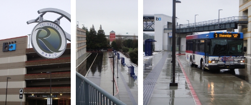
Given the station’s constraints, the connections provided to local bus service are not that bad. A comfortable shelter served by LAVTA’s recently launched Tri-Valley Rapid bus service, located on the Pleasanton side, is reasonably accessible from the station, although one must walk past or through the parking garage to reach the stop. On the Dublin side, a line of shelters was installed along the edge of the parking garage within a reasonable walk, although the number of shelters overstates the level of transit service provided; currently only one bus stops there.

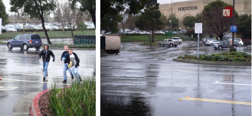
As SF Cityscape (an ever observant and insightful commenter on wayfinding) pointed out on our excursion, there are opportunities for the new station’s signage to convey information more simply and intuitively — which became comically clear when one of the few people we encountered inquired how one might get to the station from the far side of a parking garage. But a particularly egregious design error on the Pleasanton side was the lack of a crosswalk linking the station and the Rapid bus stop to Stoneridge Shopping Center. Given that the shopping center is one of few walkable destinations from this station, this is a natural location to provide a crosswalk to facilitate pedestrian passage. Instead, pedestrians sprinted frantically across a five-lane arterial to access transit from the shopping center.

Bottom Line: To the extent that it encourages commuters who now drive to ride BART instead, West Dublin/Pleasanton will be a positive development. The station has been characterized in fashionable terms as an innovative infill station spurring smart growth — which it will, to a certain extent. But this project is at heart the postponed arrival of an older concept that does not epitomize good urban design. Expectations that this station will prove to be a model of 21st century transit-oriented development should be tempered accordingly.


Great piece! It’s goot to realize how we keep getting pulled back to old models as we try to push forward.
Posted by Brant Arthur | 22 February 2011, 12:30 pmVery informative article. Unfortunately, as you discovered on your trip we have a ways to go in how we design and think about public transit. Not installing some sort of crosswalk or pedestrian-friedly traffic calming design element between the station and the mall was a major fail. The pic you posted of the pedestrians was very telling! I used to work at the mall, and always thought that incorporating some sort of mixed-use development there would help somewhat in making that area more vital and less single-use.
Posted by Joel | 22 February 2011, 1:42 pmI visited the new station today. Compared to the old Dublin station, I noticed barely adequate bike parking, and it’s much further away from the station.
At the old station, the Bikelink lockers are across from the station entrance (under the freeway). Other racks are even closer.
At the new station, I saw a couple of wave racks on the ground floor of the Pleasanton garage, away from the elevator/stairs. I suppose they’re about as close as any of the car parking, but it’s still a hike from there to the station. I didn’t come across any Bikelink lockers.
Posted by MikeOnBike | 22 February 2011, 4:52 pmMaybe BART and good design just don’t go together? For example, at the Bayfair BART station there are also no good signs directing pedestrians to the Bayfair Mall or to Hesperian Blvd.
Posted by grrljock | 23 February 2011, 11:21 amEven with a proper crosswalk on Stoneridge Mall Road, there’s still the problem of crossing the mall’s parking moat on foot. All the buildings outside the perimeter of the road have the same problem. There are basically no dedicated pedestrian paths between the mall and the perimeter road, except perhaps at Springdale on the south side.
Posted by MikeOnBike | 23 February 2011, 4:25 pmI’ve been to the station earlier in the afternoon to check it out. I thought of going on Saturday but got discouraged because of the weather. I agree with the observations you made.
Compared to the first Dublin station, this stop has some places like Stoneridge Mall where people can go to within walking distance. The bad part is that the pedestrian connection was neglected. It is something that BART and the mall owner will have to fix, and I hope that it doesn’t take somebody to get hurt to fix it. I also don’t consider putting a fence to discourage pedestrians as a fix either.
Places like malls attract teenagers, which are likely to rely on transit because many of them aren’t old enough to drive. BART serves plenty of malls so that idea shouldn’t be new.
The other things that bother me is the lack of signage from the streets to the station. From either side there’s no signage stating the name of the station (dah!) and there’s no directions from the street to the station. There’s no direction to tell which level to take the elevator on until you got inside the elevator (at that point the level of the station is placed by the button on a sticker). From the north, there’s no alternate direction for people from the street that need elevators. You see stairs but there’s no obvious path to get from the bottom of the stairs to the garage where the elevators are located.
Posted by Andy Chow | 23 February 2011, 8:07 pm