Transbay Blog
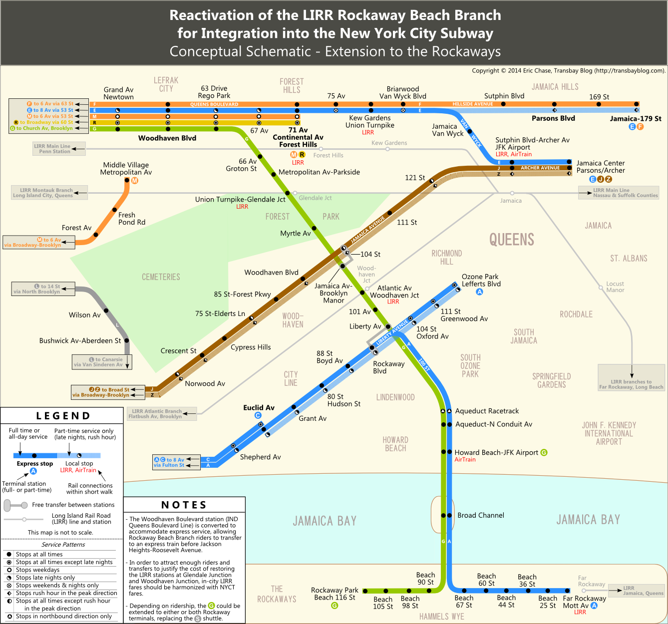
The Rockaway Beach Branch of the Long Island Rail Road (LIRR), which traces a north-south path through several central and southern neighborhoods in the New York City borough of Queens, enjoyed passenger rail service for the greater part of a century, from the late 1800s until 1962. In 1955, the City acquired the right-of-way with a plan for future subway service and built, as a provision for such service, turnout tunnels between the 63 Drive-Rego Park and 67 Avenue stations, connecting to the two outer (local) tracks of the four-track IND Queens Boulevard line. Subway service was extended to the Rockaways using the southern portion of the right-of-way just one year after the City purchased the line, but the right-of-way remains abandoned north of Liberty Avenue. Over the decades, different uses have encroached on the former rail branch and much of the right-of-way is now characterized by overgrown vegetation. Nonetheless, the desire persists to make better use of this valuable public asset. The first map below depicts one alternative for restoring transit service to this corridor: a subway line that follows the abandoned northern portion and reconnects it to the southern portion.

Excerpt from subway alternative map. Click through for full diagram.
Subway Alternative (Service Schematic)
It was not all that long ago that the G train (the only subway service that does not enter Manhattan, setting aside shuttles) made all local stops on Queens Boulevard during evenings and weekends. Even this part-time service was somewhat sporadic, and the G was officially taken off Queens Boulevard as part of the 2010 MTA service cuts. The part-time nature of G service in all but two stations in Queens was partly attributable to the difficulty in reliably turning around three full-time local services at the 71-Continental Avs station in Forest Hills, which operates as the local terminal. But a third local service could be added if it does not burden that terminal, and the Rockaway Beach Branch connection would conveniently divert those additional local trains off of Queens Boulevard just shy of 71-Continental. The map depicts the return of the G train to Queens Boulevard: full-time and extended onto the Rockaway Beach Branch using the previously built turnouts north of 63 Drive. Although one could also run the M or R (the other two local trains on Queens Boulevard) on this line, for a number of reasons, this map favors the G.
North of Liberty Avenue, the map identifies potential station locations — perhaps more stations than would be built, though the average spacing (eight stops along a roughly 3.5-mile corridor) is fairly typical for New York City subways. These are not identical to the original LIRR stations, but they are suggested with an eye toward both facilitating transfers and current and potential future land uses. 66 Av-Groton St is accessible to apartment blocks in Rego Park that are south of the LIRR main line and a schlep from Queens Boulevard, while Union Turnpike-Glendale Junction is adjacent to the high-rise Forest View Crescent co-op. Existing suburban strip mall parcels near Metropolitan Av-Parkside and Union Turnpike-Glendale Junction could be redeveloped for higher density, as could the low-rise commercial corridor on Metropolitan Avenue itself. A stop at Myrtle Av seems less likely to be built — a significant portion of the walkable radius around the station is parkland, and the original LIRR station at this location, then named Brooklyn Hills, was short-lived, closing in 1911 after the LIRR Brooklyn Manor station was built at Jamaica Avenue. But if one were built, it would serve the postwar apartment blocks lining 98 Street near Woodhaven. The stops at Jamaica Av-Brooklyn Manor and Atlantic Av-Woodhaven Junction both mirror legacy LIRR stations at these locations and provide access to commercial corridors. Similarly, the two stations at 101 Av and Liberty Av in Ozone Park each serve commercial corridors that are zoned more generously than nearby residential side streets. These eight stops north of Liberty Avenue collectively allow transfers to the A, J and Z trains; to several bus routes (including the Q54 on Metropolitan, the Q55 on Myrtle, the Q56 on Jamaica, the Q24 on Atlantic, the Q8 on 101 Av, and the Q7, Q41 and Q112 at Liberty); and, potentially, to the LIRR if stops were restored on the Montauk and Atlantic branches. South of Liberty Avenue, G and A trains would share track and stations until the G terminal at Howard Beach-JFK Airport. The map leaves unchanged the current service pattern in the Rockaways, but if justified by ridership, the G could be extended further to one of the Rockaway terminals to replace the Rockaway shuttle.
None of this would come cheaply, of course. Having a (mostly) available right-of-way is itself a big leg up, but rehabilitating it after more than a half-century of nonuse would likely require a great deal of reconstruction, and a new tunnel segment is needed to connect the Rockaway Beach Branch to Queens Boulevard. In a city with many unmet capital needs, exceptionally high construction costs and a penchant for prioritizing high-profile projects in Manhattan (despite increasing demand for improved transit links in the outer boros), assembling funds to build a new subway in Queens will be a challenge. A different sort of challenge is bringing on board neighborhoods accustomed to the right-of-way being vacant. It is fair to question whether those neighborhoods are ready to accept the new development and increased density that should accompany, and would help ensure the success of, a new transit line. It is likewise fair to evaluate ridership potential relative to other projects that will be vying for funds; although a Rockaway Beach Branch subway will enhance transit options for neighborhoods in the city that currently suffer some of the longest commutes, existing development patterns along the right-of-way suggest that this line will likely have rather light ridership compared to many other lines. And yet the potential benefits of a new subway, particularly one that is “perpendicular” to existing parallel trunk lines and would turn those parallel lines into a grid, are tantalizing — too tantalizing to allow the Rockaway Beach Branch to be squandered on QueensWay — the well-intentioned, but nonetheless misguided, push to bring a High Line-inspired elevated park to this part of Queens without reserving space for either a near-term or (more likely) long-term transit project.
Please click to here to view the full subway map.
Subway Extension to the Rockaway Peninsula
The above map maintains the existing A/S bifurcated subway service on the Rockaway Peninsula by terminating the G at Howard Beach. While this arrangement provides a rail connection to Queens Boulevard for neighborhoods that now lack such a connection, riders coming from the Rockaways would still have to execute a series of transfers to reach Queens Boulevard or Midtown Manhattan. An alternative arrangement would provide direct, one-seat service to Queens Boulevard from the Rockaways by extending the G along the Rockaway Beach Branch to either Rockaway Park or Mott Avenue.
The benefits and tradeoffs of this extended G should be considered to devise the optimal service pattern. Such an extension would add considerable length to the route and would require additional rolling stock to serve stations that, at the present time, have low ridership — but then again, faster and more convenient service would draw new riders. In addition, the opening of the Broad Channel bridge is a source of delay for subway trips, and running two full-length subway services over the bridge would create delays on both services. At least in the case of the A, unreliability on the main line can be tempered by trains that originate on the Lefferts branch, as well as local C trains further down the line. For the G, there are no such alternatives, and a bridge-related delay would perpetuate on the line all the way to Brooklyn without supplemental service on branches to pick up the slack — unless some G trains were to terminate at Howard Beach. Another question is how service should be distributed between the two Rockaway terminals. In any case, for discussion purposes I prepared a second subway map that extends the G all the way to Rockaway Park.
Please click here to view the subway map with extended G train.

Excerpt from LIRR alternative track map. Click through for full diagram.
LIRR to Aqueduct Alternative (Track Schematic)
Although my preference is for a subway on the Rockaway Beach Branch, at the request of the Queens Public Transit Committee (the principal local organization advocating that the right-of-way be reserved first and foremost for transportation purposes), I drew a track diagram that depicts an alternative with LIRR service. This alternative would maintain A train service to the Rockaways while refashioning the Aqueduct Racetrack subway station (which currently only has uptown service) as the LIRR terminal station; this terminal would be connected with the Aqueduct-N Conduit Av subway station in an accessible complex. LIRR and subway would share the Rockaway Beach Branch right-of-way until the subway tracks turn onto Liberty Avenue. LIRR tracks would then continue north along the right-of-way up to the main line. Features of this track diagram include:
- The original four-track layout at Ozone Park, which served historically as a transfer point between main line and Atlantic Branch trains (although these tracks would be excessive without round-robin or other service planned south of Aqueduct).
- An Atlantic Branch connection for direct service to Flatbush Avenue terminal and Barclays Center.
- Historical stations restored at Woodhaven Junction (Atlantic Avenue), Brooklyn Manor (Jamaica Avenue), Parkside (Metropolitan Avenue) and a main line station at Rego Park to be served by Penn Station trains.
- The IND Queens Boulevard subway line is depicted at the far left of the track diagram as a geographic reference point.
Please click here to view the full track map.
Discussion
2 thoughts on “Rockaway Beach Branch (Queens, New York)”
Leave a comment
Subscribe


Links

If you are interested in California water issues, you may want to check out my other blog on that topic.
Copyright © 2007-2021 Transbay Blog.


Great analysis. I’d like to throw in a thought about extending the G. While you are correct that having the G peel off at 63rd would enable it to run without the terminal issues I think that the very nature of the G not entering Manhattan would make it less desirable to send down the Rockaway Branch.
The best train would be the M for a few reasons. First it runs down 6th Ave and would be the best in terms of connecting the most number of travelers to offices and hotels in Midtown. Second it would offer much more frequent service to Manhattan than the G. Third, the G always requires a transfer to get to Manhattan which would require upgrading Woodhaven Blvd station to and express station (a good thing in general but this would add to the cost).
The G train would be better used as additional local service to Jamaica-179th St as the terminal there has enough capacity to service E, F, and G trains even at rush hour. Local-to-express transfers would take place in less crowded stations than Woodhaven Blvd or Jackson Heights which would improve the flow of passengers along Queens Blvd.
Now in terms of using Howard Beach as a terminal this runs into the issue that the current station was never designed as a terminal so you’d have to extend the new service to Rockaway just to be able to turn trains around. Sure you could completely rebuild the station but why bother when for cheaper you could just increase service to the Rockaways. Probably the best terminal would be Rockaway Park as it would do away with the current shuttle situation.
As the M train runs only during weekdays along Queens Blvd the never used Roosevelt Ave terminal at Jackson Heights station could be brought into service to facilitate a late night/weekend shuttle service from Roosevelt Ave to Rockaway Park; the H train which was originally designated to run such a route before the city scaled back their Rockaway subway plans. Such a service would act as a second Crosstown subway and add service along some of the heavier ridden stations on Queens Blvd.
Posted by vanshnookenraggen | 26 August 2015, 9:23 pm#1: The M train is too long already, so no sending any existing subway lines.
#2: We can build a shuttle train instead because the line is very short, maybe extend the Rockaway Shuttle to make it run via the RBB?
Posted by Mike Oxlong | 3 May 2023, 12:36 pm