Over a year ago, before this website was born, the conceptual proposals were released for Bay Area regional rail expansion projected for the next 50 years. Included among the plans is a second tube for the San Francisco-Oakland Transbay corridor, providing additional core capacity for a crucial regional link that is already a bottleneck point and which will one day reach capacity. There should be four tracks to accommodate both high speed rail and BART, but there is still the question as to what the alignment of San Francisco’s new BART line should be. As is often the case for plans associated with BART and MTC, the proposals leave something to be desired:
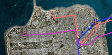
For reference, the current BART line and stations are marked in blue. One alternative (pink) connects the Transbay Transit Center to the Presidio Transit Center via Folsom, Van Ness, and Lombard. The second alternative (purple), connects 4th & Townsend to Geary & 33rd Avenue, via Townsend, Division, Van Ness, and Geary. Both routings serve the intersection of Van Ness and Market (the station marked in yellow), as they were designed to facilitate an awkward transfer to the existing BART line at Civic Center Station. Routes were also designed to serve destinations that have emerged as regional destinations in the 35 years that have elapsed since BART’s debut — notably Mission Bay, Phone Company Ball Park, and South of Market.
But does that alone make either of these the best choice? The second alternative along Geary, between Van Ness and 33rd Avenue, has the advantage of serving most of Geary, but it skips downtown altogether, forcing riders whose origin or destination is downtown to transfer. The first alternative at least serves Transbay, but then it does not address the high-demand Geary corridor at all. Both alignments have the considerable disadvantage that they skirt around the Bay Area’s densest, most transit-dependent neighborhoods, where close to three-quarters of residents do not own cars, and which are filled with both local and regional destinations. The Geary corridor, which is currently very dense and yet chock full of opportunities for further infill, has already positioned itself as an ideal corridor whose riders would make thorough use of an expensive BART investment. Including the multiple branches of the 38-Geary, the 38L-Geary Limited, the parallel bus routes to the north and south of Geary, and the various Richmond District rush hour express routes, there is a current bus ridership of over 110,000 daily riders in this corridor, about half of whom are riding on Geary itself. This figure is already close to 1/3 of BART’s daily ridership, and it does not even include those who are now driving to downtown but who could be convinced to take transit, if only “transit” meant a relatively smooth, 15-minute BART ride instead of a bumpy, jam-packed 40-minute bus ride. And here’s a note for anyone reading this who might happen to be in charge: when planning this alignment, please, please, please ride the 38-Geary; at least 250 times. Previous conversations I have had with some folks at BART make it abundantly clear that many have not bothered to acquaint themselves with the mysterious world of Muni. It is often the case that articulated buses traveling outbound on the 38 route are packed to the brim and on the verge of overflowing well before reaching Van Ness. The eastern segment of Geary is a gold mine of riders who should be delivered directly to and from downtown.
That said, Folsom and South of Market in general will be a very different place in 50 years. The innermost portion of Folsom will be a new neighborhood commercial strip for Rincon Hill, with a lively streetscape punctuated by slender high-rises — and, to be fair, Rincon Hill will be the Bay Area’s new densest neighborhood. But as long as the new BART line directly serves the Transbay Transit Center, as it should, Rincon Hill will enjoy a convenient BART connection, and it still remains to be seen the extent to which high densities in that one relatively small area will spread westward to create a new high-demand transit corridor. Hopefully, that is exactly what will happen — in response to the Central Subway, Fourth Street at least may be upzoned to support a new urban canyon. When high-density development does spread west, deeper into South of Market, we absolutely should have high-quality transit to accommodate the thousands of new residents who could potentially live there, as the current sketchy bus service in that area will be insufficient. But “high-quality transit” does not automatically imply BART. Anyway, for another expensive pipe dream that involves this corridor: check out the next post.


the 38 Geary bus was meant only as a temporary, stop gap measure. They took out the B line because they didn’t want duplicate rail service in anticipation of BART’s expansion down Geary.
That sure worked out well, didn’t it?
Posted by njudah | 2 July 2008, 11:36 amIt doesn’t take a genius to figure out that BART needs to run the length of Geary from downtown to at least Presidio where it could turn south, run through the park and down 19th Ave. to the existing Daly City BART station. Both corridors are ripe for smart, transit-oriented development.
Posted by Mark De George | 2 July 2008, 4:19 pmI love this site and I’m so happy people are talking about transit investment and infrastructure. BART down Geary is a necessity- as you mentioned the 38 is packed to it’s articulated seams and much of the street is ripe for more density. I agree that the line would need to go to at least Park Presidio (some trains could continue out Geary) and then turn south following 19th Ave. connecting up with the existing BART station at Daly City. For those who don’t see the ridership potential or need I’d like to point out that the Fillmore, Western Addition, Laurel Heights, and RIchmond – Indeed the entire northern third of the city – have no good (fast and direct) – access to the southwestern portion of the city – Golden Gate Park, Irving and Taraval shopping and Restaurants, Stern Grove, Stonestown, San Francisco State – not to mention a direct connection to SFO after Daly City. I can see thousands of people daily utilizing the link down 19th Ave. as well as thousands more commuting to their jobs downtown.
I think stations on the south side of the park at Judah/Irving, Taraval, and maybe one at Stonestown as well as San Francisco State would be a good idea. But what do people imagine on the Geary side? . A stop on Fulton to access the park. A stop on Geary at Park Presidio. But between Park Presidio and Van Ness? 5th or 6th Ave. on Geary? One at Masonic and Geary? One at Divisadero?Fillmore? Also curious about cost estimates and the engineering realities of tunneling under downtown and under existing subway infrastructure to make this happen… Any ideas?
Posted by James | 10 September 2008, 8:56 pm